Tinsukia

Tinsukia
Tinsukia
Localidad de la India
Tinsukia  তিনিচুকীয়া
Tinsukia
তিনিচুকীয়া
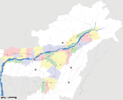
Ubicación de Tinsukia en Assam.
Ubicación de Assam en India.
27°29′22″N 95°21′21″E / 27.48944, 95.35583Coordenadas: 27°29′22″N 95°21′21″E / 27.48944, 95.35583
Entidad Localidad
 • País Bandera de India India
 • Estado Assam
 • Distrito Tinsukia
Altitud  
 • Media 127 msnm
Población (Est.2010[1] )  
 • Total 94.085 hab.
Huso horario IST UTC +5:30
PIN[2] 786125
Código de área 374

Tinsukia (en asamés: তিনিচুকীয়া ) es una localidad de la India, centro administrativo del distrito de Tinsukia, estado de Assam.

Contenido

Geografía

Se encuentra a una altitud de 127 msnm a 506 km de la capital estatal, Dispur, en la zona horaria UTC +5:30.

Demografía

Según estimación 2010 contaba con una población de 94 085 habitantes.[1]

Referencias

Enlaces externos


Wikimedia foundation. 2010.

Игры ⚽ Поможем написать реферат

Mira otros diccionarios:

  • Tinsukia — Infobox Indian Jurisdiction native name = Tinsukia | type = city | latd = 27.5 | longd = 94.37 locator position = left | state name = Assam district = Tinsukia leader title = leader name = altitude = 116 population as of = 2001 population total …   Wikipedia

  • Tinsukia — Original name in latin Tinsukia Name in other language Tinsukia State code IN Continent/City Asia/Kolkata longitude 27.48905 latitude 95.35992 altitude 128 Population 89373 Date 2012 10 06 …   Cities with a population over 1000 database

  • Tinsukia — Admin ASC 2 Code Orig. name Tinsukia Country and Admin Code IN.03.7627085 IN …   World countries Adminstrative division ASC I-II

  • Tinsukia district — Tinsukia is one of the twenty three administrative districts n the state of Assam in India. The district headquarters are located at Tinsukia. The district occupies an area of 3790 km² and has a population of 1,150,146 (as of 2001). History The… …   Wikipedia

  • Tinsukia — ▪ India       town, northeastern Assam state, far northeastern India. It is located in the Brahmaputra River valley at a rail junction, about 25 miles (40 km) east of Dibrugarh. It is linked by highway with northwestern Myanmar (Burma) to the… …   Universalium

  • Don Bosco High School, Tinsukia — Location Don Bosco School,Gelapukhuri Road, Tinsukia Information Number of students 700 Approximately Principal Fr. Nazarius Lakra, SDB Vice Principal Fr. Sanjeev Linda, SDB …   Wikipedia

  • Makum —   city   …   Wikipedia

  • Digboi —   city   …   Wikipedia

  • Dibrugarh district — This article is about the district. For its eponymous headquarters, see Dibrugarh. Dibrugarh district   District   …   Wikipedia

  • Ledo Road — The Ledo Road, (from Ledo, Assam, India to Kunming, Yunnan, China) was built during World War II so that the Western Allies could supply the Chinese as an alternative to the Burma Road which had been cut by the Japanese in 1942. It was renamed… …   Wikipedia

Compartir el artículo y extractos

Link directo
Do a right-click on the link above
and select “Copy Link”