Waipapa Point

Waipapa Point
Punta Waipapa
(Waipapa Point)
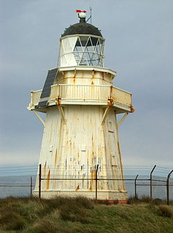
Waipapa point lighthouse.jpg
Vista del faro de punta Waipapa
Localización administrativa
País Bandera de Nueva Zelanda Nueva Zelanda
División Región de Southland
Localización geográfica
Continente (o sub) Oceanía
Archipiélago Islas de Nueva Zelanda
Isla Isla Sur
Mar (océano) Océano Pacífico Sur)
Coordenadas 46°39′35.92″S 168°50′49.37″E / -46.6599778, 168.8470472Coordenadas: 46°39′35.92″S 168°50′49.37″E / -46.6599778, 168.8470472
Mapa de localización
Punta Waipapa
Punta Waipapa
Geolocalización en Nueva Zelanda
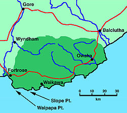
Localización en un mapa de la región

Localización en un mapa de la región

La punta Waipapa (en inglés: Waipapa Point es un promontorio rocoso en la costa meridional de la Isla Sur, en Nueva Zelanda. Se encuentra a 10 kilómetros al sureste de la desembocadura del río Mataura, en el extremo suroccidental del área conocida como The Catlins.

La línea costera de The Catlins es muy peligrosa, habiendo ocurrido muchos naufragios en la zona. El más notable de ellos, además del mayor desastre marino de Nueva Zelanda, fue el hundimiento del vapor de pasajeros Tararua, en ruta entre Bluff y Port Chalmers, que se hundió en punta Waipapa el 29 de abril de 1881, ahogándose 20 de los 151 pasajeros.

Tras la tragedia se construyó un faro en este lugar, que comenzó a operar en 1884. Actualmente se mantiene activo, funcionando automáticamente desde 1976. Es uno de los últimos faros que se construyeron en madera en el país.

Enlaces externos


Wikimedia foundation. 2010.

Игры ⚽ Нужен реферат?

Mira otros diccionarios:

  • Waipapa Point — is a rocky promontory on the south coast of the South Island of New Zealand. It is located 10 kilometres (6 miles) southeast of the mouth of the Mataura River, at the extreme southwestern end of the area known as the Catlins.The coastline of the… …   Wikipedia

  • Waipapa Point — Leuchtturm auf Waipapa Point Waipapa Point ist ein Felsenkap an der Südküste der Südinsel Neuseelands. Es befindet sich 10 km südöstlich der Mündung des Mataura River am äußersten südwestlichen Ende der Catlins. Am 28./29. April 1881 kam es… …   Deutsch Wikipedia

  • Waipapa Point Lighthouse — Infobox lighthouse|name= Waipapa Point Ligthhouse location= Waipapa Point, South Island, New Zealand caption= coordinates = 46°39.8 S 168°50.7 E yearbuilt = 1883 yearlit = 1884 yeardeactivated= automated= 1976 intensity= elevation= 21 m range= 16 …   Wikipedia

  • SS Tararua — Zeitgenössische Darstellung des Schiffbruches Die SS Tararua war ein neuseeländischer Passagierdampfer. Er lief am 29. April 1881 auf ein Riff vor Waipapa Point vor den Catlins auf der Südinsel Neuseelands auf und sank am folgenden Tag. Dies war… …   Deutsch Wikipedia

  • Catlins — The Catlins (manchmal auch The Catlins Coast) ist ein Gebiet im Südwesten der Südinsel Neuseelands zwischen Balclutha und Invercargill. Es streift die Grenze zwischen den Regionen Otago und Southland und umfasst auch den südlichsten Punkt der… …   Deutsch Wikipedia

  • Tararua (Schiff) — Zeitgenössische Darstellung des Schiffbruches Die Tararua war ein neuseeländischer Passagierdampfer. Er lief am 29. April 1881 auf ein Riff vor Waipapa Point vor den Catlins auf der Südinsel Neuseelands auf und sank am folgenden Tag. Dies war das …   Deutsch Wikipedia

  • The Catlins — (sometimes referred to as The Catlins Coast) comprises an area in the southeastern corner of the South Island of New Zealand. The area lies between Balclutha and Invercargill, straddling the boundary between the Otago and Southland regions. It… …   Wikipedia

  • The Catlins — (manchmal auch The Catlins Coast) ist ein Gebiet im Südwesten der Südinsel Neuseelands zwischen Balclutha und Invercargill. Es streift die Grenze zwischen den Regionen Otago und Southland und umfasst auch den südlichsten Punkt der Südinsel, Slope …   Deutsch Wikipedia

  • The Catlins — Localización de The Catlins en la Isla Sur de Nueva Zelanda. Localización País: Nueva Zelanda Isla: Isla Sur …   Wikipedia Español

  • SS Tararua — was a passenger steamer that struck the reef off Waipapa Point in the Catlins on 29 April 1881, and sank the next day, in the worst civilian shipping disaster in New Zealand s history. [http://library.christchurch.org.nz/Kids/NZDisasters/SSTararua… …   Wikipedia

Compartir el artículo y extractos

Link directo
Do a right-click on the link above
and select “Copy Link”