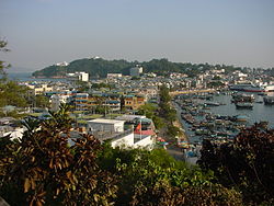
Cheung Chau

Cheung Chau
Isla Cheung Chau
長洲
Western sight of Cheung Chau.jpg
Vista de la isla
Localización
País Bandera de la República Popular China China
Región administrativa especial Flag of Hong Kong.svg Hong Kong
Coordenadas 22°12′38″N 114°01′44″E / 22.21056, 114.02889Coordenadas: 22°12′38″N 114°01′44″E / 22.21056, 114.02889
Geografía
Superficie 2,45 km²
Demografía
Población 24.312 (2006)
Densidad 9882,93 hab./km²
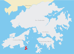
Cheung Chau location map.svg
Cheung Chau en el mapa de Hong Kong, China

Cheung Chau (chino: 長洲, literalmente «isla larga») es una pequeña isla localizada a 10 km al suroeste de la isla de Hong Kong, apodada como "isla pesa" por su particular forma. Ha sido habitada durante más tiempo que la mayoría de otros lugares del territorio de Hong Kong, con una población de unos 23.000 habitantes en 2006. Administrativamente, forma parte del las "Islas del Distrito".

Contenido

Geografía

Geográficamente, la isla está formado por dos masas de granito que en su mayoría se unieron por lo que fue probablemente una vez un tómbolo, una especie de banco de arena. Con una superficie de 2,45 km²,[1] la isla es alargada, de ahí que el nombre traducido del chino cantonés sea Isla Larga. La isla esta en forma de mancuerna, con colinas en los extremos norte y sur y los asentamientos concentrados en el medio.

Véase también

Referencias

Enlaces externos


Wikimedia foundation. 2010.

Игры ⚽ Поможем написать реферат

Mira otros diccionarios:

  • Cheung Chau — Not to be confused with Changzhou Island, an island in Guangzhou, China. The village of Cheung Chau, viewed from the north. The bay of Tung Wan is on the left and Cheung Chau Typhoon Shelter is on the right. Cheung Chau (Chinese: 長洲, lit. Long… …   Wikipedia

  • Cheung Chau — Localisation de Cheung Chau Cheung Chau (chinois: 長洲, pinyin: Chángzhōu, « Ile longue ») est une petite île située à une dizaine de kilomètres au sud ouest de l île de Hong Kong. Faisant partie administrativement du District des Iles… …   Wikipédia en Français

  • Cheung Chau Public Pier — (Chinese: 長洲公眾碼頭) is a public pier in Cheung Chau, New Territories, Hong Kong, located in Praya Street, with Cheung Chau Ferry Pier located between it and the Cheung Chau Typhoon Shelter. It is used for loading and unloading of goods …   Wikipedia

  • Cheung Chau Bun Festival — A mountain of buns to be climbed for the festival Cheung Chau Bun Festival (Chinese: 包山節; Jyutping: baau1 saan1 zit3) or Cheung Chau Da Jiu Festival (Chinese: 長洲太平清醮; Jyutping: coeng4 zau1 taai3 ping4 cing1 ziu3) is a traditional …   Wikipedia

  • Warwick Hotel Cheung Chau Hong Kong (Hong Kong) — Warwick Hotel Cheung Chau Hong Kong country: Hong Kong, city: Hong Kong (Island: Cheung Chau) Warwick Hotel Cheung Chau Hong Kong Divest yourself of hectic city lives when you stay at the Warwick Hotel Cheung Chau Hong Kong. Boasting breathtaking …   International hotels

  • Warwick Hotel Cheung Chau — (Гонконг,Гонконг) Категория отеля: 3 звездочный отель Адрес: East Bay, Che …   Каталог отелей

  • Cheung Po Tsai — Type Pirate Place of birth Xinhui, Jiangmen, China Allegiance Qing Dynasty Years active c. 1800 1810 Rank Admiral …   Wikipedia

  • Cheung Po Tsai — (Cantonés, Jēung Bóu Jái en transcripción Yale) o Chang Pao Tsai (en Wade Giles) (chino tradicional: 張保仔, chino simplificado: 张保仔, pinyin: Zhāng Bǎozǎi) fue un pirata chino del siglo XIX. También se lo conocía como Cheung Po/Chang… …   Wikipedia Español

  • Chau Tsai Kok — (Chinese: 洲仔角) is a small uninhabited island off the island of Tap Mun in the northeastern New Territories of Hong Kong, opposite to the village of Tap Mun. It is under the administration of Tai Po District …   Wikipedia

  • Chau Tsai — Map of Chan Tsai and Nam Wan Kok, Tsing Yi Islands before reclamation Chau Tsai (Chinese: 洲仔) was a small island off the southern shore, Nam Wan Kok, of Tsing Yi Island of Hong Kong. It was also known as Chun Fa Rock (Chung Hue Rock), or Chung… …   Wikipedia

Compartir el artículo y extractos

Link directo
Do a right-click on the link above
and select “Copy Link”