Gaerwen

Gaerwen
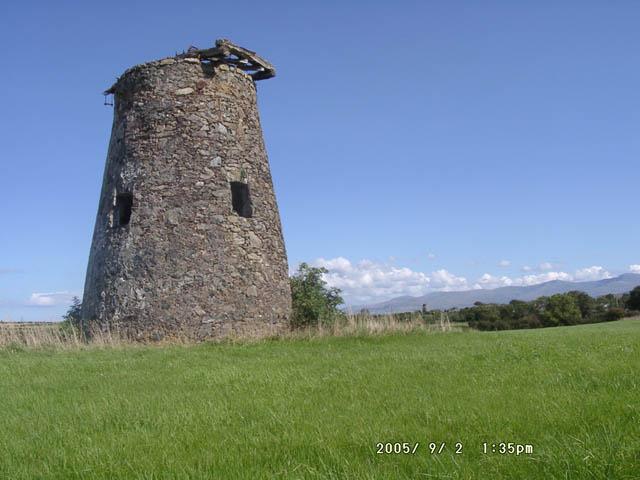
Uno de los molinos de biento de Gaerwen

Gaerwen es un pueblo en la isla de Anglesey, al norte de Wales. Se sitúa al sur de la isla 5 millas al oeste de Llanfairpwllgwyngyll y a sólo unos pocos metros al sur de la A55.

Es un pueblo con sus partes antiguas y sus partes nuevas con dos molinos de viento ya en desuso al norte del pueblo y una central industrial moderna. Entre las instalaciones hay pubs, una oficina de correos y una escuela primaria. Antes había un Little Chef justo al salir del pueblo, el cual se cerró hace algunos años.

Sin embargo, el pueblo es más famoso probablemente por albergar la estación más meridional del Ferrocarril Central de Anglesey, que estuvo en uso entren 1864 y 1993. También se usaba en la línea principal de Bangor a Holyhead hsata 1963.

Star es un diminuto asentamiento compuesto por unas 20 casas unas 1,5 millas al este del pueblo.

Enlaces externos

Coordenadas: 53°12′N 4°16′O / 53.2, -4.267


Wikimedia foundation. 2010.

Игры ⚽ Поможем решить контрольную работу

Mira otros diccionarios:

  • Gaerwen — is a village on the island of Anglesey, north Wales. It is located in the south of the island 4 miles west of Llanfairpwllgwyngyll and just a few hundred metres south of the A55. It is very much a village of the old and new with two disused… …   Wikipedia

  • Gaerwen — Original name in latin Gaerwen Name in other language Gaerwen State code GB Continent/City Europe/London longitude 53.22112 latitude 4.27362 altitude 59 Population 3065 Date 2012 04 12 …   Cities with a population over 1000 database

  • Gaerwen railway station — Infobox UK disused station| name = Gaerwen| locale = Gaerwen| borough = Anglesey| manager = LNWR owner = LMS years = 1865 events = OpenedFact|date=April 2008| years1 = 1966| events1 = ClosedFact|date=April 2008 latitude = 53.2126 longitude =… …   Wikipedia

  • Anglesey Central Railway — The Anglesey Central Railway (Welsh: Lein Amlwch , Amlwch Line ) was a 17.5 mile (28 kilometre) long railway in Anglesey, Wales, connecting the port of Amlwch and the county town of Llangefni with the North Wales Coast Line at Gaerwen. Built as… …   Wikipedia

  • Anglesey — For other places with the same name, see Anglesey (disambiguation). Isle of Anglesey Ynys Môn Geography Area Total  % Water …   Wikipedia

  • A55 road — The A55 at Warren Mountain. Route information …   Wikipedia

  • Anglesey League — The Anglesey Football League (currently the Stena Line Anglesey Football League , for sponsorship reasons) is a football league and is equivalent to the fifth level of the Welsh football league system in North Wales. The champions are promoted to …   Wikipedia

  • Red Wharf Bay branch line — The Red Wharf Bay branch line was a standard gauge railway line in Anglesey, Wales and branched off the Anglesey Central Railway. It was the last standard gauge passenger line to open in North Wales,Rear; 1994] in 1908, but it closed to… …   Wikipedia

  • Anglesey — 53°17′N 4°20′W / 53.283, 4.333 Île d Ang …   Wikipédia en Français

  • Ynys Môn — Anglesey Wikipédia …   Wikipédia en Français

Compartir el artículo y extractos

Link directo
Do a right-click on the link above
and select “Copy Link”