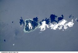
Gunungapi Wetar

Gunungapi Wetar
Gunungapi Wetar
Wetarvolc.jpg
Tipo Estratovolcán
Ubicación mar de Banda, Indonesia
 • Coordenadas 6°38′31″S 126°39′0″E / -6.642, 126.65
Altitud 282 msnm[1]
Superficie

Gunungapi Wetar es un isla volcánica aislada ubicada al norte de la isla Wetar en el mar de Banda, Indonesia. La isla, un estratovolcán, tiene una elevación de solo 282 m sobre el nivel del mar, pero la altura hasta la cumbre desde el fondo oceánico es superior a los 5000 m. Se tiene registro de dos erupciones en 1512 y 1699.[1]

Referencias

  1. a b «Gunungapi Wetar». Global Volcanism Program. Consultado el 7 de septiembre de 2011.

Wikimedia foundation. 2010.

Игры ⚽ Поможем решить контрольную работу

Mira otros diccionarios:

  • Gunungapi Wetar — Infobox Mountain Name=Gunungapi Wetar Photo= Caption= Elevation=282 metres (925 feet)cite web|title=Gunungapi Wetar|work=Global Volcanism Program|publisher=Smithsonian Institution|url=http://www.volcano.si.edu/world/volcano.cfm?vnum=0605… …   Wikipedia

  • Wetar — Infobox Islands name = Wetar image caption = locator Location map|Indonesia|lat= 7.8|long=126.3 map custom = yes native name = native name link = location = South East Asia coordinates= coord|7|48|S|126|18|E|region:ID type:isle archipelago =… …   Wikipedia

  • Îles Barat Daya — Kepulauan Barat Daya (id) Géographie Pays   …   Wikipédia en Français

  • Liste des volcans d'Indonésie — Carte d Indonésie indiquant les principaux volcans entrés en éruption depuis 1900. Cet article recense les volcans d Indonésie. Sommaire 1 Caractéristiques …   Wikipédia en Français

  • Barat Daya Islands — The Barat Daya Islands (Indonesian: Kepulauan Barat Daya ) are a group of islands in the Maluku province of Indonesia. The Indonesian phrase barat daya means south west , referring to the islands location relative to the capital of Maluku… …   Wikipedia

  • Liste von Vulkanen in Indonesien —  Karte mit allen Koordinaten: OSM, Google oder …   Deutsch Wikipedia

  • Yersey — Infobox Seamount Name=Yersey Location map|Maluku Topography |lat= 7.53|long=123.95 |width=300 |float=center|label= |caption= |mark=Wallpaper group diagram legend rotation3.svg|marksize=16 |background=none Depth= Convert|3800|m|ft| 3?cite… …   Wikipedia

  • Sangeang — Pulau Sangeang. Satellitenaufnahme der NASA unmittelbar nach Beginn des Ausbruchs im Jahre 1985 …   Deutsch Wikipedia

  • Wallacean Drongo — Conservation status Least Concern (IUCN 3.1) Scientific classification Kingd …   Wikipedia

Compartir el artículo y extractos

Link directo
Do a right-click on the link above
and select “Copy Link”