- U.S. Route 150 (Illinois)
-

U.S. Route 150 Illinois,
  Estados Unidos
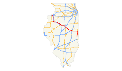
Mapa de la U.S. Route 150Identificador 150 Tipo Ruta Federal Inauguración 1926 Longitud 430,4 km (267.47 mi)[1] Orientación oeste a este • oeste • este  US 150 en la frontera con Indiana
Cruces Administración IDOT Anterior:
 IL 149
Siguiente:
 IL 150
La U.S. Route 150 o Ruta Federal 150 (abreviada US 150) es una autopista federal ubicada en el estado de Illinois. La autopista inicia en el oeste desde la US 6 en Moline hacia el este en la US 150 en la frontera con Indiana.[2] La autopista tiene una longitud de 430,4 km (267.47 mi).[3]
Contenido
Mantenimiento
Al igual que las carreteras estatales, las carreteras interestatales, y el resto de rutas federales, la U.S. Route 150 es administrada y mantenida por el Departamento de Transporte de Illinois por sus siglas en inglés IDOT.
Cruces
La U.S. Route 150 es atravesada principalmente por la
 I 55
I 55  I 57
I 57  I 74 .
Véase también
 Portal:Illinois. Contenido relacionado con Illinois.
Referencias
- ↑ «Longitud de la U.S. Route 150». Departamento de Transporte de los Estados Unidos. Consultado el 19 de septiembre de 2011.
- ↑ «Lista de extremos, salidas y longitud de la Ruta Federal 150». U.S. Highways.com. Consultado el 19 de septiembre de 2011.
- ↑ Google, Inc. «Google Maps –Recorrido de la U.S. Route 150». Google, Inc. Consultado el 19 de septiembre de 2011.
Enlaces externos
 Wikimedia Commons alberga contenido multimedia sobre U.S. Route 150 (Illinois). Commons
- Página oficial del IDOT
- Lista de ciudades servidas por autopistas federales}
- Lista de Autopistas por estado en AARoads.com
Coordenadas:
Categoría:- Carreteras federales de Illinois

Wikimedia foundation. 2010.