Chateaubelair

Chateaubelair
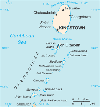
Chateaubelair al sur del volcán La Soufrière, y al norte de Kingstown.

Chateaubelair es un gran poblado de pescadores ubicado al oeste de la isla caribeña de San Vicente, la isla principal de San Vicente y las Granadinas. Se encuentra justo al sur del volcán de Soufrière. Comúnmente denominado simplemente "Chateau", es el enfoque y la comunidad más grande del Norte de San Vicente, y la cuarta ciudad más grande en el país.

Entre los lugares de interés se encuentran cascadas y rocas talladas de valor arqueológico, las cuales se creen que han sido dejadas por los indígenas Caribeños.

Muchas actividades están disponibles todo el año, incluyendo la pesca submarina, y la más común para el Caribe en general, el dominó, baloncesto, fútbol y críquet. La economía local es apoyada principalmente por la agricultura.

Véase también

Coordenadas: 13°17′N 61°15′O / 13.283, -61.25


Wikimedia foundation. 2010.

Игры ⚽ Поможем решить контрольную работу

Mira otros diccionarios:

  • Chateaubelair — Chateaubelair, Saint Vincent and the Grenadines Location Map Chateaubelair is a large fishing village on the Leeward (west) coast of the Caribbean island of Saint Vincent, the main island of Saint Vincent and the Grenadines. It is located just… …   Wikipedia

  • Chateaubelair — Administration Pays  Saint Vincent et les Grenadines …   Wikipédia en Français

  • Chateaubelair — Original name in latin Chateaubelair Name in other language Chateaubelair, Richmond, Richmond Town State code VC Continent/City America/St Vincent longitude 13.28333 latitude 61.25 altitude 142 Population 735 Date 2012 02 17 …   Cities with a population over 1000 database

  • Saint-David (Saint-Vincent-et-les Grenadines) — Pour les articles homonymes, voir Saint David (homonymie) et David. Saint David …   Wikipédia en Français

  • Saint-david (saint-vincent-et-les grenadines) — Pour les articles homonymes, voir Saint David (homonymie) et David. Saint David …   Wikipédia en Français

  • San David (San Vicente y las Granadinas) — Saltar a navegación, búsqueda San David (inglés: Saint David Parish) junto con otras cinco parroquias mas forman las seis divisiones administrativas de San Vicente y las Granadinas. Posee una superficie de ochenta kilómetros cuadrados y una… …   Wikipedia Español

  • Saint Vincent And The Grenadines — Introduction Saint Vincent and the Grenadines Background: Disputed between France and the United Kingdom in the 18th century, Saint Vincent was ceded to the latter in 1783. Autonomy was granted in 1969, and independence in 1979. Geography Saint… …   Universalium

  • Saint-David (Saint-Vincent-et-les-Grenadines) — 13°17′03″N 61°14′29″O / 13.28417, 61.24139 …   Wikipédia en Français

  • Saint Vincent (island) — You may be looking for St. Vincent Island, FloridaInfobox Islands name = Saint Vincent image caption = Villa, St. Vincent, 1890s image size = locator map custom = yes native name = native name link = nickname = location = Caribbean Sea… …   Wikipedia

  • List of cities, towns and villages in Saint Vincent and the Grenadines — This is a list of cities, towns and villages in Saint Vincent and the Grenadines:* Barrouallie * Chateaubelair * Georgetown * Kingstown 15,670 (capital) * Layou * Port Elizabeth * Ashton, Union Island * Clifton, Union Island * Arnos Vale *… …   Wikipedia

Compartir el artículo y extractos

Link directo
Do a right-click on the link above
and select “Copy Link”