Kitaa

Kitaa
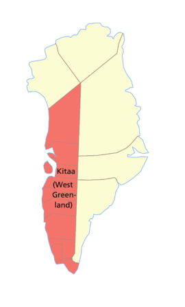
Mapa de Groenlandia Occidental.

Kitaa/Vestgrønland (Groenlandia Occidental) fue la más poblada de las tres antiguas regiones (amt) en las que se dividia Groenlandia hasta 2009, albergando a casi el 90% de la población total. Su capital era también la capital groenlandesa, Nuuk.

Limitaba al oeste con la bahía de Baffin, estrecho de Davis, mar del Labrador y el océano Atlántico. Por el este limitaba con Groenlandia Oriental.

Todos los municipios de la isla, a excepción de tres, se encuentraban en Groenlandia Occidental. En orden geográfico,de sur a norte eran:


Wikimedia foundation. 2010.

Игры ⚽ Нужно сделать НИР?

Mira otros diccionarios:

  • Kitaa — Vestgrønland (Groenland occidental) Administration Pays …   Wikipédia en Français

  • Kitaa — Kitaa/Vestgrønland (West Greenland) is the most populous of the three counties ( amt ) of Greenland, being home to almost 90% of the total population. The county seat is the Greenlandic capital, Nuuk.It is bordered in the west by the Baffin Bay,… …   Wikipedia

  • Kitaa — Kitaa, in der türkischen Poesie ein Gedicht von vier bis acht Strophen, mit verschiedenen Reimen …   Pierer's Universal-Lexikon

  • Kitaa — Karte von Westgrönland. Kitaa/Vestgrønland (Westgrönland) war bis 2009 einer der drei Verwaltungsbezirke (amt) von Grönland. Es wohnen fast 90 % der gesamten Bevölkerung auf diesem Gebiet. Der Verwaltungssitz war die grönländische Hauptstadt …   Deutsch Wikipedia

  • Administrative divisions of Greenland — Greenland This article is part of the series: Politics and government of Greenland Prime Minister Kuupik Kleist …   Wikipedia

  • Subdivisions du groenland — Découpage administratif du Groenland depuis le 1er janvier 2009. En gris, le Parc national du Nord Est du Groenland …   Wikipédia en Français

  • Holsteinborg — Sisimiut Holsteinsborg Sisimiut vom Nasaasaaq Kommune Qeqqata Kommunia Geographische Lage …   Deutsch Wikipedia

  • Subdivisions du Groenland — Découpage administratif du Groenland depuis le 1er janvier 2009. En gris, le Parc national du Nord Est du Groenland …   Wikipédia en Français

  • Divisiones administrativas de Groenlandia — desde el 1 de enero de 2009. En gris, el Parque Nacional del Noreste de Groenlandia. Groenlandia está dividida en cuatro municipalidades y dos zonas no incorporadas. Esta división, efectuada par la fusión de las antiguas municipalidades… …   Wikipedia Español

  • Groenland-Occidental — 68°00′N 52°00′W / 68, 52 …   Wikipédia en Français

Compartir el artículo y extractos

Link directo
Do a right-click on the link above
and select “Copy Link”