- Makanrushi
-
 Makanrushi
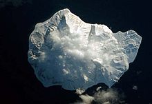
Makanrushi (en ruso, Маканруши) es una isla rusa en el archipiélago de las Kuriles. Tiene una superficie de 49 km². Pertenece al grupo de las Kuriles septentrionales.
Geografía
Al sureste se encuentra la isla Onekotan, separada por el estrecho de Evreinov.
La isla de Makanrushi se encuentra entre las coordenadas geográficas siguientes:
Al sureste se encuentra la isla Onekotan, separada por el estrecho de Evreinov.
Administrativamente es controlada por el Óblast de Sajalín.
Categoría: Islas del archipiélago de las Kuriles

Wikimedia foundation. 2010.