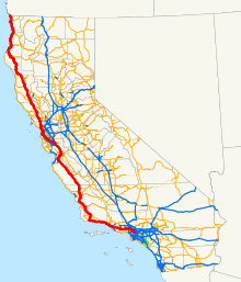
- U.S. Route 101 (California)
-

Ruta Federal 101 California
Nombre coloquial Santa Ana Freeway, Hollywood Freeway, Ventura Freeway, Bayshore Freeway, Central Freeway, Redwood Highway Tipo Carretera federal Inauguración 1926 Longitud 808.111 mi (1301 km) Orientación Sur a Norte • Sur 
 I-5/SR 60 en Los Ángeles
• Norte  US 101 en Oregón
Cruces  en Ventura
 en Santa María
 en Salinas
 en San José
 en San Francisco
 cerca de Ukiah
 cerca de Eureka
Sistema Carreteras estatales de California(lista)
Sin construir - Autovías - EscénicasMantenida por Caltrans
En el estado estadounidense de California, la U.S. Route 101 (también conocida como Highway 101 (Carretera 101), La 101, o simplemente como 101) es una de las últimas rutas que quedan y más activas de las ruta federales en el estado, y la carretera más larga de cualquier tipo en California.[1] La US 101 fue una de las originales rutas federales establecidas en 1926.Esta ruta es parte del Sistema de Autovías y Vías Expresas de California y es una carretera escénica.[2]
Referencias
- ↑ [http://www.cahighways.org/stats1.html California Highways Highway Statistics]
- ↑ CA Codes (shc:250-257)
Enlaces externos
Drive the 101 - Contains historical information.
 Wikimedia Commons alberga contenido multimedia sobre U.S. Route 101 (California). Commons
Categorías:- Carreteras federales de California
- Registro Nacional de Lugares Históricos de California
- Autovías de California
- Carreteras del condado de Los Ángeles
- Carreteras del condado de Ventura
- Carreteras del condado de Santa Bárbara
- Carreteras del condado de Monterrey
- Carreteras del condado de San Benito
- Carreteras del condado de San Luis Obispo
- Carreteras del condado de Santa Clara
- Carreteras del condado de San Mateo
- Carreteras del condado de Marin
- Carreteras del condado de Sonoma
- Carreteras del condado de Mendocino
- Carreteras del condado de Humboldt
- Carreteras del condado de Del Norte
- Carreteras escénicas de California
- Carreteras en el Registro Nacional de Lugares Históricos
Wikimedia foundation. 2010.
