Uunartoq

Uunartoq
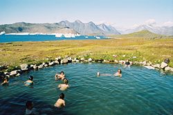
Aguas termales en Uunartoq.

Uunartoq es una localidad en la municipalidad de Kujalleq, en el sur de Groenlandia. Se ubica en la isla de Uunartoq, cercana a la localidad de Alluitsup Paa y está a 40 m sobre el nivel del mar.

Es conocida como un destino turístico por sus fuentes hidrotermales con temperaturas entre 34 y 38 grados Celsius.[1]

En esta isla se pueden encontra las ruinas de asentamientos anteriores de finales del siglo XVIII y comienzos del siglo XIX.[1] También existen las ruinas de un convento cercano a las fuentes de aguas termales, construido posterior a la cristianización de Groenlandia, alrededor del año 1000.

Notas

  1. a b Elliott, Mark (2005). Greenland and the Arctic. Lonely Planet. pp. 123-4. ISBN 1-74059-095-3. 

Lectura recomendada

  • Vebœk, C. L. The Church Topography of the Eastern Settlement and the Excavation of the Benedictine Convent in Uunartoq Fjord. Copenhagen: Kommissionen for Videnskabelige Undersøgelser i Grønland, 1991. ISBN 87-17-06236-5

Wikimedia foundation. 2010.

Игры ⚽ Поможем написать реферат

Mira otros diccionarios:

  • Uunartoq — is a town (latitude of 69.9 degrees and longitude of 52.60 degrees) on the island of Uunartoq off the west coast of Greenland. It is 40 meters (134 feet) above sea level. There are geothermal springs in Uunartoq that emerge with temperatures of… …   Wikipedia

  • Uunartoq — Vorlage:Infobox Insel/Wartung/Fläche fehlt Uunartoq Baden mit Eisbergen im Hintergrund Gewässer Uunartoq Fjord …   Deutsch Wikipedia

  • Uunartoq Qeqertoq — Uunartoq Qeqertoq, Kalaallisut for The Warming Island , is an island discovered in September 2005 by American explorer Dennis Schmitt off the east central coast of Greenland, 550 km ( 340 mi) north of the Arctic circle. It was attached to the… …   Wikipedia

  • Uunartoq Qeqertoq — Vorlage:Infobox Insel/Wartung/Fläche fehltVorlage:Infobox Insel/Wartung/Höhe fehlt Uunartoq Qeqertoq Blick von Uunartoq Qeqertoq auf das zurück …   Deutsch Wikipedia

  • Uunartoq Qeqertoq — El nuevo estrecho originado tras la retirada de la capa de hielo. Imagen tomada desde Uunartoq Qeqertoq en 2006 …   Wikipedia Español

  • Uunartoq Qeqertoq — 71°29′N 21°51′W / 71.483, 21.85 …   Wikipédia en Français

  • Warming Island — Blick von Uunartoq Qeqertoq auf das zurückgehende Eis. Uunartoq Qeqertoq (Kalaallisut, auf englisch Warming Island ( erwärmende Insel )) ist eine unbewohnte Insel östlich von Grönland. Sie liegt etwa 650 km nördlich des arktischen Polarkreises.… …   Deutsch Wikipedia

  • Arktische Klimaveränderung — Die zur Arktis zählenden Gebiete sind auf dieser Weltkarte grün eingefärbt. Eine Satellitenaufnahme mit der Arktis im Zentrum, dank technisc …   Deutsch Wikipedia

  • Arktische Klimaveränderungen — Die zur Arktis zählenden Gebiete sind auf dieser Weltkarte grün eingefärbt. Eine Satellitenaufnahme mit der Arktis im Zentrum, dank technisc …   Deutsch Wikipedia

  • Eisschmelze — Die Massenbalance der globalen Gletscher ist seit wenigstens 1960 deutlich negativ, wie das Schaubild verdeutlicht …   Deutsch Wikipedia

Compartir el artículo y extractos

Link directo
Do a right-click on the link above
and select “Copy Link”