Adalaj

Adalaj
Adalaj
Localidad de la India
Adalaj  અડાલજ
Adalaj
અડાલજ
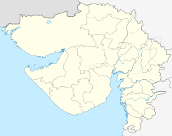
Ubicación de Adalaj en Guyarat.
23°09′50″N 72°34′50″E / 23.16389, 72.58056Coordenadas: 23°09′50″N 72°34′50″E / 23.16389, 72.58056
Entidad Localidad
 • País Bandera de India India
 • Estado Guyarat
 • Distrito Gandhinagar
Altitud  
 • Media 70 msnm
Población (Est.2011[1] )  
 • Total 11.297 hab.
Huso horario IST UTC +5:30
PIN[2] 382421
Código de área 2712

Adalaj (en guyaratí: અડાલજ ) es una ciudad de la India en el distrito de Gandhinagar, estado de Guyarat.

Contenido

Geografía

Se encuentra a una altitud de 70 msnm a 12 km de la capital estatal, Gandhinagar, en la zona horaria UTC +5:30.

Demografía

Según estimación 2011 contaba con una población de 11 297 habitantes.[1]

Referencias

Enlaces externos


Wikimedia foundation. 2010.

Игры ⚽ Поможем сделать НИР

Mira otros diccionarios:

  • Adalaj — Infobox Indian Jurisdiction native name = Adalaj | type = city | latd = 23.17 | longd = 72.58 locator position = right | state name = Gujarat district = Gandhinagar leader title = leader name = altitude = 68 population as of = 2001 population… …   Wikipedia

  • Adalaj — Original name in latin Adalaj Name in other language Adalaj State code IN Continent/City Asia/Kolkata longitude 23.16453 latitude 72.58107 altitude 70 Population 10423 Date 2013 01 10 …   Cities with a population over 1000 database

  • Dilwara Temples — The Jain Dilwara temples of India are located about 2½ kilometers from Mount Abu, Rajasthan s only hill station. These temples built by Chalukya[1][2] b …   Wikipedia

  • Stepwell — Stepwells, also called bawdi (Hindi:बावड़ी) or baoli ( [Hindi:बावली), are in essence wells in which the water can be reached by descending a set of steps. They may be covered and protected, and are often of architectural significance. It can be… …   Wikipedia

  • Ahmadabad — Wappen Karte Basisdaten Bundesstaat: Gujarat Regierungsbezirk: Ahmedabad …   Deutsch Wikipedia

  • Gandhinagar — Infobox Indian Jurisdiction native name = Gandhinagar type = capital latd = 23.22 longd = 72.68 locator position = right skyline = SACHIVALAY PANORAMA.jpg skyline caption = Panorama of the Gujarat Legislative Assembly state name = Gujarat… …   Wikipedia

  • List of India-related articles — Articles (arranged alphabetically) related to India or Indian culture include: NOTOC List of India related topics People are listed by their first names. 1231 SGM 3 STR 2002 Gujarat violence 2005 in India ( previous years ) 2004 Indian Ocean… …   Wikipedia

  • Historical timeline of Ahmedabad — This page provides a Historical timeline of Ahmedabad, the sixth largest city in India. For an overview of Ahmedabad, see Ahmedabad. Up to 15th century* 1074 Karnadeva won Aashavalli and established Karnavati. * 1094 to 1143 Shantuvihar and… …   Wikipedia

  • Modh — are the followers of Modheshwari Maa (also known as Matangi Maa), a form of Amba Maa with eighteen hands. They originally lived in a town called Modhera in Patan District in the northern part of Gujarat. The name of the town Modhera was adopted… …   Wikipedia

  • Karamsad — is a city and a municipality in Anand district in the Indian state of Gujarat. It is part of the Chchagaam Gol ( Circle of Six Villages ). Sardar Vallabhbhai Patel, one of India s greatest leaders in the Indian Independence Movement grew up in… …   Wikipedia

Compartir el artículo y extractos

Link directo
Do a right-click on the link above
and select “Copy Link”