Adstone

Adstone
Adstone
Pueblo y parroquia civil del Reino Unido
All Saints', Adstone - geograph.org.uk - 143072.jpg
Adstone
Adstone
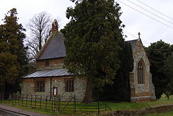
Ubicación en Northamptonshire.
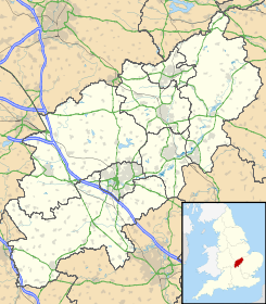
52°9′32.5368″N 1°7′51.8484″O / 52.159038, -1.131069Coordenadas: 52°9′32.5368″N 1°7′51.8484″O / 52.159038, -1.131069
Entidad Pueblo y parroquia civil
 • País Bandera del Reino Unido Reino Unido
 • Nación constitutiva Inglaterra
 • Región Midlands del Este
 • Condado Northamptonshire
 • Distrito South Northamptonshire
Población (2001)  
 • Total 84 hab.
Código postal NN12
Prefijo telefónico 01327

Adstone es un pueblo y una parroquia civil del distrito de South Northamptonshire, en el condado de Northamptonshire (Inglaterra).

Demografía

Según el censo de 2001, Adstone tenía 84 habitantes (45 varones y 39 mujeres). 10 de ellos (11,9%) eran menores de 16 años, 69 (82,14%) tenían entre 16 y 74, y 5 (5,95%) eran mayores de 74. La media de edad era de 46,68 años. De los 74 habitantes de 16 o más años, 18 (24,32%) estaban solteros, 48 (64,87%) casados, y 8 (10,81%) divorciados o viudos.[1] 46 habitantes eran económicamente activos, todos ellos empleados.[2] Había 3 hogares sin ocupar y 40 con residentes.[3]

Evolución demográfica de Adstone
1881 1891 1901 1911 1921 1931 1941 1951 1961
151 138 112 137 111 112 - 99 80
(Fuente:Vision of Britain )

Referencias

  1. «Adstone - People» (en inglés). Office for National Statistics. Consultado el 5 de julio de 2011.
  2. «Adstone - Work and Qualifications» (en inglés). Office for National Statistics. Consultado el 5 de julio de 2011.
  3. «Adstone - Accommodation and Tenure» (en inglés). Office for National Statistics. Consultado el 5 de julio de 2011.

Enlaces externos


Wikimedia foundation. 2010.

Игры ⚽ Поможем написать курсовую

Mira otros diccionarios:

  • Adstone — infobox UK place country = England latitude= 52.1586longitude= 1.1293official name= Adstone population = 65 (2001) shire district= South Northamptonshire shire county = Northamptonshire region= East Midlandsconstituency westminster= Daventry post …   Wikipedia

  • South Northamptonshire — For the parliamentary constituency, see South Northamptonshire (UK Parliament constituency). South Northamptonshire Council   District   …   Wikipedia

  • Long Mynd — The Long Mynd in Shropshire, England, is a part of the Shropshire Hills Area of Outstanding Natural Beauty. It is convert|10|mi|km south of the county town Shrewsbury, and has an area of over 22 square kilometres (8.5 sq mi). The name Long Mynd… …   Wikipedia

  • List of places in Northamptonshire — This is a list of places in the ceremonial county of Northamptonshire, United Kingdom. See the list of places in England for places in other counties See also compactTOC NOTOC AAbington Abthorpe Achurch Adstone Alderton Aldwincle Althorp… …   Wikipedia

  • Farthingstone — infobox UK place country = England latitude= 52.11 longitude= 1.06 official name= Farthingstone population = 179 (2001) shire district= Daventry shire county = Northamptonshire region= East Midlands constituency westminster= Daventry post town=… …   Wikipedia

  • List of civil parishes in Northamptonshire — This is a list of civil parishes in Northamptonshire, England. Most parishes have their own parish council, but some smaller parishes may have a parish meeting, or may join together to form a combined parish council. Some larger parishes have… …   Wikipedia

  • Maidford — Coordinates: 52°10′03″N 1°06′31″W / 52.1674°N 1.1087°W / 52.1674; 1.1087 …   Wikipedia

Compartir el artículo y extractos

Link directo
Do a right-click on the link above
and select “Copy Link”