Alangulam

Alangulam
Alangulam
Localidad de la India
Alangulam  ஆலங்குளம்
Alangulam
ஆலங்குளம்
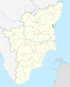
Ubicación de Alangulam en Tamil Nadu.
Ubicación de Tamil Nadu en India.
8°51′54″N 77°29′58″E / 8.865, 77.49944Coordenadas: 8°51′54″N 77°29′58″E / 8.865, 77.49944
Entidad Localidad
 • País Bandera de India India
 • Estado Tamil Nadu
 • Distrito Tirunelveli
Altitud  
 • Media 125 msnm
Población (Est.2010[1] )  
 • Total 32.097 hab.
Huso horario IST UTC +5:30
PIN 627851
Código de área +04633

Alangulam (en tamil: ஆலங்குளம் ) es una localidad de la India en el distrito de Tirunelveli, estado de Tamil Nadu.

Contenido

Geografía

Se encuentra a una altitud de 125 m.s.m. a 560 km de la capital estatal, Chennai, en la zona horaria UTC +5:30.

Demografía

Según estimación 2010 contaba con una población de 32 097 habitantes.[1]

Referencias

Enlaces externos


Wikimedia foundation. 2010.

Игры ⚽ Нужна курсовая?

Mira otros diccionarios:

  • Alangulam — may refer to,* Alangulam (Virudhunagar district), a town in Virudhunagar district, Tamil Nadu in India * Alangulam (Tirunelveli district), a town in Tirunelveli district, Tamil Nadu in India …   Wikipedia

  • Alangulam — Original name in latin langulam Name in other language Alangulam, Atangulam, langulam, tangulam State code IN Continent/City Asia/Kolkata longitude 8.86404 latitude 77.49937 altitude 125 Population 28558 Date 2013 02 08 …   Cities with a population over 1000 database

  • Alangulam (Tirunelveli district) — Infobox Indian Jurisdiction native name = Alangulam | type = city | latd = 8.87 | longd = 77.5 locator position = right | state name = Tamil Nadu district = Tirunelveli leader title = leader name = altitude = 127 population as of = 2001… …   Wikipedia

  • Alangulam (Virudhunagar district) — Infobox Indian Jurisdiction native name = Alangulam | type = city | latd = 9.94 | longd = 77.57 locator position = right | state name = Tamil Nadu district = Virudhunagar leader title = leader name = altitude = 127 population as of = 2001… …   Wikipedia

  • Tirunelveli district — This article is about the district. For its eponymous headquarters, see Tirunelveli. Tirunelveli District Nellai   district   …   Wikipedia

  • Cheranmahadevi block — is a revenue block in the Tirunelveli district of Tamil Nadu, India. It has a total of 12 panchayat villages. References Map of revenue blocks of Tirunelveli district . Government of Tamil Nadu. http://tnmaps.tn.nic.in/default.htm?blocks.php?dcode… …   Wikipedia

  • Cheranmahadevi division — is a revenue division in the Tirunelveli district of Tamil Nadu, India. References Map of Revenue divisions of Tirunelveli district . http://tnmaps.tn.nic.in/default.htm?rev div.php?dcode=29 …   Wikipedia

  • Manur block — is a revenue block in the Tirunelveli district of Tamil Nadu, India. It has a total of 41 panchayat villages. References Map of revenue blocks of Tirunelveli district . Government of Tamil Nadu. http://tnmaps.tn.nic.in/default.htm?blocks.php?dcode… …   Wikipedia

  • Melaneelithanallur block — is a revenue block in the Tirunelveli district of Tamil Nadu, India. It has a total of 25 panchayat villages. References Map of revenue blocks of Tirunelveli district . Government of Tamil Nadu. http://tnmaps.tn.nic.in/default.htm?blocks.php?dcode… …   Wikipedia

  • Mottaiyar River — Mottaiyar is a river flowing in the Tirunelveli district of the Indian state of Tamil Nadu. References [1] See also List of rivers of Tamil Nadu …   Wikipedia

Compartir el artículo y extractos

Link directo
Do a right-click on the link above
and select “Copy Link”