Chilov

Chilov
Isla Chilov
Çilov Adasi
Localización
País Bandera de Azerbaiyán Azerbaiyán
Mar Mar Caspio
Coordenadas 40°20′N 50°35′E / 40.333, 50.583Coordenadas: 40°20′N 50°35′E / 40.333, 50.583
Geografía
Punto más alto 8 m
Otros datos
Ciudad Bakú
Distrito Khazar
Península Absheron
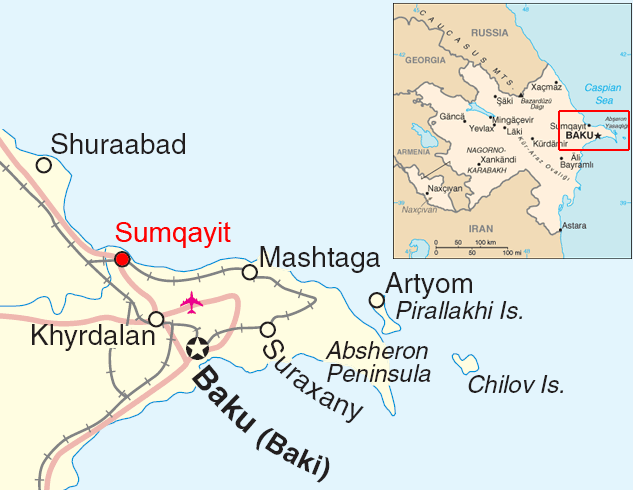
Azerbaijan map sumqayit.png
Mapa de Localización

Chilov (en Azerbaiyano: Çilov Adasi, también deletreado Zhiloy y Jiloi) es una isla en la Península Absheron, 55 km al este de Bakú, en el país caucásico de Azerbaiyán.

La isla Chilov está a 25 km del extremo oriental de la Península Absheron, a 100 kilómetros de Bakú.

Posee unos 10 km de diámetro y tiene una forma irregular con diferentes ensenadas. Su elevación más alta alcanza los 8 metros.

Administrativamente la isla Chiloy pertenece al distrito de Khazar de Bakú.

Contenido

Historia

Los yacimientos de petróleo y gas fueron descubiertos cerca de la isla Chilov por los Rusos, dirigidos por el almirante y conde Marko Vojnović mientras estaban en una expedición en el Mar Caspio en 1781[1]

Véase también

Enlaces externos

Referencias


Wikimedia foundation. 2010.

Игры ⚽ Поможем написать реферат

Mira otros diccionarios:

  • Chilov — Map showing Chilov Island off the eastern tip of the Apsheron Peninsula. Chilov (Azerbaijani: Çilov adası, also spelt Zhiloy and Jiloi) is an island off the Absheron Peninsula, 55 km east of Baku. Chilov Island is located 25 km off the eastern… …   Wikipedia

  • Antibody — Immunoglobulin redirects here. For the immunoglobulin family, see Immunoglobulin superfamily. Antibodies redirects here. For the film, see Antibodies (film). Each antibody binds to a specific antigen; an interaction similar to a lock and key. An… …   Wikipedia

  • List of Azerbaijan-related articles — Articles (arranged alphabetically) related to the Azerbaijan Republic include:#26 Baku Commissars 26 Commissars Memorial 1842 Baku earthquake 2000 Baku earthquakeA.az Abbasgulu Bakikhanov Abdulla Shaig Abdurahman Fatalibeyli Abülfaz Elçibay… …   Wikipedia

  • Platelet-derived growth factor — (PDGF) Identifiers Symbol PDGF Pfam PF00341 InterPro …   Wikipedia

  • Pirallahi Island — Pirallahi Pirallahi Island off the Apsheron Peninsula Geography Location Caspian Sea Coordinates …   Wikipedia

  • Vascular endothelial growth factor C — is a VEGF. The human gene encoding it is VEGFC. PBB Summary section title = summary text = The protein encoded by this gene is a member of the platelet derived growth factor/vascular endothelial growth factor (PDGF/VEGF) family, is active in… …   Wikipedia

  • Chistoy Banki — or Chistaya Banka is an island in the Caspian Sea. It is located off the mouths of the Volga, 27 km south of the southern tip of Zyudev Island. Chistoy Banki Island has a length of 6 km and a maximum width of 4 km. Administratively …   Wikipedia

  • Ogurja Ada — Location of Ogurja Ada. 19th century Russian map of Ogurchinskiy Island …   Wikipedia

  • Chechen Island — Location of Chechen Island. Chechen Island (Остров Чечень; Ostrov Chechen ), is a coastal island in the Caspian Sea. It is located 20 km east of Krainovka right off a landhead on the western shore of the Caspian. The island has a length of… …   Wikipedia

  • Mark Voynovich — Count Mark Ivanovich Voynovich ( ru. Марк Иванович Войнович; 1750 1807) was an Admiral of the Russian Imperial Navy, one of the founders of the Black Sea Fleet [http://gatchina3000.ru/great soviet encyclopedia/bse/006/174.htm Voynovich, Mark… …   Wikipedia

Compartir el artículo y extractos

Link directo
Do a right-click on the link above
and select “Copy Link”