Gilston

Gilston
Gilston
Parroquia civil y pueblo del Reino Unido
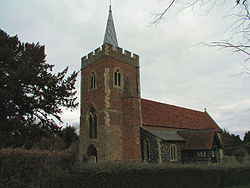
St. Mary's Church, Gilston - geograph.org.uk - 140191.jpg
Iglesia de Santa María, en Gilston.
Gilston
Gilston
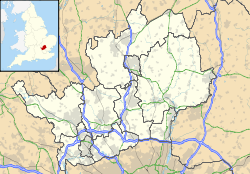
Ubicación de Gilston en Hertfordshire.
51°47′33.2″N 0°5′51.4″E / 51.792556, 0.097611Coordenadas: 51°47′33.2″N 0°5′51.4″E / 51.792556, 0.097611
Entidad Parroquia civil y pueblo
 • País Bandera del Reino Unido Reino Unido
 • Nación constitutiva Inglaterra
 • Región Este de Inglaterra
 • Condado Hertfordshire
 • Distrito East Hertfordshire
Superficie  
 • Total 3,93 km²
Población (2001)  
 • Total 180 hab.
 • Densidad 45,8 hab/km²
Huso horario GMT (UTC0)
 • en verano BST (UTC +1)
Código postal CM20

Gilston es una parroquia civil y un pueblo del distrito de East Hertfordshire, en el condado de Hertfordshire (Inglaterra).

Contenido

Geografía

Según la Oficina Nacional de Estadística británica, Gilston tiene una superficie de 3,93 km².[1]

Demografía

Según el censo de 2001, Gilston tenía 180 habitantes (49,44% varones, 50,56% mujeres) y una densidad de población de 45,8 hab/km². El 21,67% eran menores de 16 años, el 74,44% tenían entre 16 y 74, y el 3,89% eran mayores de 74. La media de edad era de 37,97 años. Del total de habitantes con 16 o más años, el 21,99% estaban solteros, el 68,79% casados, y el 9,22% divorciados o viudos.[2]

El 97,77% de los habitantes eran originarios del Reino Unido y 2,23% del resto de países europeos. Además, todos eran blancos. El cristianismo era profesado por el 75,98%, mientras que el 17,88% no eran religiosos y el 6,15% no marcaron ninguna opción en el censo.[1]

Había 65 hogares con residentes y 3 vacíos.[2]

Referencias

  1. a b Tablas: «Usual Resident Population (KS01) for Amalgamated Parishes», «Ethnic Group (KS06) for Amalgamated Parishes», «Country of Birth (KS05) for Amalgamated Parishes» y «Religion (KS07) for Amalgamated Parishes», disponibles para descarga aquí. Office for National Statistics (inglés).
  2. a b «Area: Gilston CP (Parish)» (en inglés). Office for National Statistics. Consultado el 31 de octubre de 2011.

Enlaces externos


Wikimedia foundation. 2010.

Игры ⚽ Поможем сделать НИР

Mira otros diccionarios:

  • Gilston — Recorded in several forms including Gilston, Gilstin, Gilstoun, and perhaps Gilton, this is a surname which is almost certainly of Scottish origins, although also recorded in the north east of England. However spelt it is quite rare, and it was… …   Surnames reference

  • Gilston, New —    GILSTON, NEW, a village, in the parish of Largo, district of St. Andrew s, county of Fife, 4 miles (N. by E.) from Largo; containing 229 inhabitants. It lies in the northern part of the parish, and near its eastern boundary. In the vicinity of …   A Topographical dictionary of Scotland

  • Cargill Gilston Knott — Naissance 30 juin 1856 …   Wikipédia en Français

  • Cargill Gilston Knott — (June 30, 1856 mdash;October 26, 1922) was born at Penicuik, Scotland. He was a pioneer in seismological research, working in Japan 1883 – 91. His writings display a broad interest in knowledge. Knott was a student and collaborator of Peter… …   Wikipedia

  • High Sheriff of Hertfordshire — This is a list of High Sheriffs of Hertfordshire.William I, William II, Henry I, Stephen* Ibert * Peter de Valoignes * Edward de Saresburg * Geoffrey de Magnaville * Stephen * Alberie de Vere, Jun, and *1139 Richard Bassett, Justices of England * …   Wikipedia

  • Den Nye By — Studio album by The Dreams Released February 8, 2008 …   Wikipedia

  • Gilstoun — Recorded in several forms including Gilston, Gilstin, Gilstoun, and perhaps Gilton, this is a surname which is almost certainly of Scottish origins, although also recorded in the north east of England. However spelt it is quite rare, and it was… …   Surnames reference

  • The Incredible String Band — Infobox musical artist Name = Incredible String Band Img capt = Background = group or band Origin = Edinburgh / Glasgow, Scotland Genre = Psychedelic folk, world music Years active = 1965 1974 1999 2006 Label = Elektra Records (1966 70) Island… …   Wikipedia

  • Soroban — The Also, when the suanpan was imported to Japan, it came along with it its division table. The method using the table was called [http://www.questia.com/PM.qst?a=o d=93950015 Free digital copy] available at Questia.] , and therefore had to… …   Wikipedia

  • County of Ward, Queensland — Ward Queensland Location within Queensland Lands administrative divisions around Ward …   Wikipedia

Compartir el artículo y extractos

Link directo
Do a right-click on the link above
and select “Copy Link”