Greywell

Greywell
Greywell
Parroquia civil y pueblo del Reino Unido
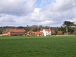
Greywell - geograph.org.uk - 147207.jpg
Vista de Greywell.
Greywell
Greywell
Ubicación de Greywell en Hampshire.
51°15′25.8″N 0°58′18.6″O / 51.257167, -0.971833Coordenadas: 51°15′25.8″N 0°58′18.6″O / 51.257167, -0.971833
Entidad Parroquia civil y pueblo
 • País Bandera del Reino Unido Reino Unido
 • Nación constitutiva Inglaterra
 • Región Este de Inglaterra
 • Condado Hampshire
 • Distrito Hart
Superficie  
 • Total 3,45 km²
Población (2001)  
 • Total 220 hab.
 • Densidad 63,77 hab/km²
Huso horario GMT (UTC0)
 • en verano BST (UTC +1)
Código postal RG29
Prefijo telefónico 01256

Greywell es una parroquia civil y un pueblo del distrito de Hart, en el condado de Hampshire (Inglaterra).

Contenido

Geografía

Según la Oficina Nacional de Estadística británica, Greywell tiene una superficie de 3,45 km².[1]

Demografía

Según el censo de 2001, Greywell tenía 220 habitantes (47,27% varones, 52,73% mujeres) y una densidad de población de 63,77 hab/km². El 15,91% eran menores de 16 años, el 75,45% tenían entre 16 y 74, y el 8,64% eran mayores de 74. La media de edad era de 44,51 años. Del total de habitantes con 16 o más años, el 21,62% estaban solteros, el 62,7% casados, y el 15,68% divorciados o viudos.[2]

El 87,84% de los habitantes eran originarios del Reino Unido. El resto de países europeos englobaban al 5,41% de la población, mientras que el 6,76% había nacido en cualquier otro lugar. Según su grupo étnico, el 97,31% eran blancos, el 1,35% mestizos, y el 1,35% asiáticos. El cristianismo era profesado por el 75,69%, mientras que el 18,81% no eran religiosos y el 5,5% no marcaron ninguna opción en el censo.[1]

Había 98 hogares con residentes y 5 vacíos.[2]

Referencias

  1. a b Tablas: «Usual Resident Population (KS01) for Amalgamated Parishes», «Ethnic Group (KS06) for Amalgamated Parishes», «Country of Birth (KS05) for Amalgamated Parishes» y «Religion (KS07) for Amalgamated Parishes», disponibles para descarga aquí. Office for National Statistics (inglés).
  2. a b «Area: Greywell CP (Parish)» (en inglés). Office for National Statistics. Consultado el 26 de octubre de 2011.

Enlaces externos


Wikimedia foundation. 2010.

Игры ⚽ Нужен реферат?

Mira otros diccionarios:

  • Greywell — is a small village in Hampshire, England. It is the birthplace of Bill Newton Dunn, an MEP for the Liberal Democrats.Greywell village has several times won the best kept village competition. It has the Basingstoke Canal running underneath part of …   Wikipedia

  • Greywell Hill —    Dr Hampshire residence of Lord Dorchester, 307 …   The makers of Canada

  • Basingstoke Canal — The Basingstoke Canal is a British Canal, built to connect Basingstoke with the River Thames at Weybridge via the Wey Navigation.From Basingstoke, the canal passes through or near Odiham, Fleet, Aldershot, Mytchett, Brookwood, and Woking. Its… …   Wikipedia

  • Leigh Park — infobox UK place country = England latitude= 50.869 longitude= 0.987 official name= Leigh Park population = Approx 27,500 official name= Leigh Park shire district= Havant shire county = Hampshire region= South East England constituency… …   Wikipedia

  • Basingstoke — Coordinates: 51°16′00″N 1°05′15″W …   Wikipedia

  • Bill Newton Dunn — Infobox MEP honorific prefix = name = Bill Newton Dune honorific suffix =MEP constituency MP = East Midlands, UK parliament = European majority = predecessor = successor = Incumbent term start = 1 May 1999 term end = birth date = Birth date and… …   Wikipedia

  • River Blackwater (River Loddon) — Geobox|River name = Blackwater (Loddon) native name = other name = other name1 = image size = image caption = River Blackwater at Eversley bridge etymology = country country = England country1 = state = state1 = region type = Counties region =… …   Wikipedia

  • Odiham — Not to be confused with odeon (disambiguation) or odium (disambiguation). Coordinates: 51°14′44″N 0°56′52″W / 51.245665°N 0.94776995°W / 51.24 …   Wikipedia

  • List of Sites of Special Scientific Interest in Hampshire — This is a list of the Sites of Special Scientific Interest (SSSIs) in Hampshire. For other counties, see List of SSSIs by Area of Search.* Alresford Pond * Ashford Hill Woods and Meadows * Avon Valley (Bickton to Christchurch) * Baddesley Common… …   Wikipedia

  • Odiham (hundred) — The Hundred of Odiham Index Map as known in the mid 1800s. The Odiham Hundred is highlighted in white. The Hundred of Odiham was a Hundred of Great Britain situated in the ceremonial county of Hampshire. The Hundred of Odiham contained the… …   Wikipedia

Compartir el artículo y extractos

Link directo
Do a right-click on the link above
and select “Copy Link”