- Hutchinson River Parkway
-
Hutchinson River
Inauguración 1940 Longitud 18.78 millas Orientación Sur a Norte • Sur Bruckner Interchange en Throgs Neck • Norte  SR 120A
  Parkway Merritt
  RT 15 en Greenwich
Cruces  I 95 en Baychester
I 95 en Eastchester
 Parkway Cross County en Mount Vernon
 I 287 en Harrison
 I 684 en Harrison
Lugares que atraviesa El Bronx, Westchester Anterior:
 NY 1B
NY 1BSiguiente:
US 2
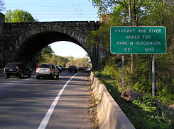
El Hutchinson River Parkway (también conocido como The Hutch) es una carretera de norte-sur del estado de Nueva York, Estados Unidos. Se extiende por 18,78 millas (30,22 km) desde la masiva Bruckner Interchange en Throgs Neck sección de the Bronx hasta la línea estatal entre Nueva York – Connecticut en Rye Brook. La carretera continua al sur de la Bruckner Interchange como Whitestone Expressway (I-678) y al norte en Greenwich, Connecticut, como Merritt Parkway. La carretera es nombrada por el estadounidense y líder religioso Anne Hutchinson.
La construcción de la vía expresa inició en 1924 y fue completada en 1941. La sección de la carretera entre Eastern Boulevard (ahora como Bruckner Boulevard) en el Bronx y la U.S. Route 1 en Pelham Manor fue designada como New York State Route 1X desde 1941 a 1946. NY 1A fue subsecuente-mente re-alineada con el Hutch entre Eastern Boulevard y US 1. La designación NY 1A fue removida en 1962.
Referencias
 Wikimedia Commons alberga contenido multimedia sobre Hutchinson River Parkway. Commons
 Portal:Nueva York. Contenido relacionado con Nueva York.
Categorías:- Carreteras de Nueva York
- Transporte de la Ciudad de Nueva York
- Transporte del Bronx
- Condado de Westchester
- Arquitectura de 1941


Wikimedia foundation. 2010.