Kalanaur

Kalanaur
Kalanaur
Localidad de la India
Kalanaur
Kalanaur
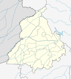
Ubicación de Kalanaur en Punyab.
32°00′48″N 75°08′51″E / 32.01333, 75.1475Coordenadas: 32°00′48″N 75°08′51″E / 32.01333, 75.1475
Entidad Localidad
 • País Bandera de India India
 • Estado Punyab
 • Distrito Gurdaspur
Altitud  
 • Media 250 msnm
Población (Est.2010[1] )  
 • Total 14.682 hab.
Huso horario IST UTC +5:30

Kalanaur es una ciudad de la India en el distrito de Gurdaspur, estado de Punyab.

Contenido

Geografía

Se encuentra a una altitud de 250 msnm a 274 km de la capital estatal, Chandigarh, en la zona horaria UTC +5:30.

Demografía

Según estimación 2010 contaba con una población de 14 682 habitantes.[1]

Referencias

Enlaces externos


Wikimedia foundation. 2010.

Игры ⚽ Поможем решить контрольную работу

Mira otros diccionarios:

  • Kalanaur — can refer to:#Kalanaur (Punjab), a town in the Indian state of Punjab #Kalanaur (Haryana), a town in the Indian state of Haryana …   Wikipedia

  • Kalanaur — 1 Original name in latin Kalanaur Name in other language Kalanaur, Kalnaur State code IN Continent/City Asia/Kolkata longitude 32.01227 latitude 75.15063 altitude 259 Population 13671 Date 2012 10 06 2 Original name in latin Kalnaur Name in other …   Cities with a population over 1000 database

  • Kalanaur (Haryana) — Infobox Indian Jurisdiction native name = Kalanaur | type = city | latd = 28.83 | longd = 76.4 locator position = right | state name = Haryana district = Rohtak leader title = leader name = altitude = 200 population as of = 2001 population total …   Wikipedia

  • Kalanaur (Punjab) — Infobox Indian Jurisdiction native name = Kalanaur | type = city | latd = 32.02 | longd = 75.15 locator position = right | state name = Punjab district = Gurdaspur leader title = leader name = altitude = 243 population as of = 2001 population… …   Wikipedia

  • Jarral — Rajput = The Jarral Rajputs (Urdu: جـرال راجپوت, also spelled Jaral, Jerral) are a prominent Muslim Rajput tribe of Azad Kashmir and Punjab provinces of Pakistan. They are well known for being the last longest ruling royal dynasty of Rajouri in… …   Wikipedia

  • Battle of Panipat (1556) — Infobox Military Conflict conflict=Second Battle of Panipat caption= partof=Mughal Wars date=November 5, 1556 (Muharram 2,964 Hijri) place=Panipat, Haryana, India result=Decisive Mughal victory combatant1= combatant2= Suri Dynasty… …   Wikipedia

  • Gurdaspur — Infobox Indian Jurisdiction native name = Gurdaspur type = city latd = 32.0333 longd = 75.40 locator position = state name = Punjab district = Gurdaspur area total = area telephone = altitude = 241 leader title = leader name = population total =… …   Wikipedia

  • Nankana Sahib District — Nankana Sahib Khairpur Bhattian   District   Nankana Sahib District Country …   Wikipedia

  • Samrat Hem Chandra Vikramaditya — Samrat Hem Chandra Vikramaditya, also known as Hemachandra Bhargava or simply Hemu (Hindi: सम्राट हेम चंद्र विक्रमादित्य) (1501 1556) was a Hindu Emperor of India during the 1500s. He fought Afghan rebelsTripathi, Dr. Ram Prasad. Bhartiya Itihas …   Wikipedia

  • Gurdaspur district — is a district in the state of Punjab, situated in the northwest part of India. Gurdaspur is the district headquarters. It borders Pakistan, Jammu and Kashmir, the Punjab districts of Amritsar and Hoshiarpur, and the state of Himachal Pradesh. Two …   Wikipedia

Compartir el artículo y extractos

Link directo
Do a right-click on the link above
and select “Copy Link”