Katangi

Katangi
Katangi
Localidad de la India
Katangi
Katangi
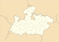
Ubicación de Katangi en Madhya Pradesh.
Ubicación de Madhya Pradesh en India.
23°08′56″N 79°56′24″E / 23.14889, 79.94Coordenadas: 23°08′56″N 79°56′24″E / 23.14889, 79.94
Entidad Localidad
 • País Bandera de India India
 • Estado Madhya Pradesh
 • Distrito Balaghat
Altitud  
 • Media 413 msnm
Población (Est.2010[1] )  
 • Total 18.553 hab.
Huso horario IST UTC +5:30
PIN[2] 481445

Katangi es una localidad de la India en el distrito de Balaghat, estado de Madhya Pradesh.

Contenido

Geografía

Se encuentra a una altitud de 413 msnm a 440 km de la capital estatal, Bhopal, en la zona horaria UTC +5:30.

Demografía

Según estimación 2010 contaba con una población de 18 553 habitantes.[1]

Referencias

Enlaces externos


Wikimedia foundation. 2010.

Игры ⚽ Поможем написать курсовую

Mira otros diccionarios:

  • Katangi — Infobox Indian Jurisdiction native name = Katangi | type = city | latd = 21.78 | longd = 79.78 locator position = right | state name = Madhya Pradesh district = Balaghat leader title = leader name = altitude = 442 population as of = 2001… …   Wikipedia

  • Katangi — 1 Original name in latin Katangi Name in other language Katangi, Nagra Katangi State code IN Continent/City Asia/Kolkata longitude 23.44168 latitude 79.79628 altitude 374 Population 17816 Date 2012 11 08 2 Original name in latin Katngi Name in… …   Cities with a population over 1000 database

  • Balaghat District — a district of Madhya Pradesh state of central India. The town of Balaghat serves as its administrative headquarters.GeographyBalaghat District is located in the southern part of Jabalpur Division. It occupies the south eastern portion of the… …   Wikipedia

  • List of India-related articles — Articles (arranged alphabetically) related to India or Indian culture include: NOTOC List of India related topics People are listed by their first names. 1231 SGM 3 STR 2002 Gujarat violence 2005 in India ( previous years ) 2004 Indian Ocean… …   Wikipedia

  • Narsinghpur — This article is about the municipality in Madhya Pradesh, India. For its namesake district, see Narsinghpur District. Narsinghpur   city   …   Wikipedia

  • Chhindwara — This article is about the municipality in Madhya Pradesh, India. For its namesake district, see Chhindwara District. Chhindwara   town   …   Wikipedia

  • Mandla — This article is about the municipality in Madhya Pradesh, India. For its namesake district, see Mandla District. Mandla मण्डला   city   …   Wikipedia

  • Chhindwara District — This article is about the district. For its eponymous headquarters, see Chhindwara. Chhindwara district छिन्दवाड़ा जिला …   Wikipedia

  • Mandla District — This article is about the district. For its eponymous headquarters, see Mandla. Mandla district मंडला जिला …   Wikipedia

  • Seoni (Madhya Pradesh) — Seoni redirects here, for a town in Shimla District see Seoni (Himachal Pradesh). Infobox Indian Jurisdiction native name = Seoni | type = city | latd = 22.08 | longd = 79.53 locator position = right | state name = Madhya Pradesh district = Seoni …   Wikipedia

Compartir el artículo y extractos

Link directo
Do a right-click on the link above
and select “Copy Link”