Kingstone (Staffordshire)

Kingstone (Staffordshire)
Kingstone
Parroquia civil y pueblo del Reino Unido
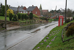
Uttoxeter Road, Kingstone - geograph.org.uk - 354386.jpg
Vista de Kingstone.
Kingstone
Kingstone
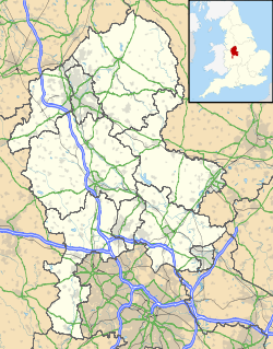
Ubicación de Kingstone en Staffordshire.
52°51′48.5″N 1°54′44.9″O / 52.863472, -1.912472Coordenadas: 52°51′48.5″N 1°54′44.9″O / 52.863472, -1.912472
Entidad Parroquia civil y pueblo
 • País Bandera del Reino Unido Reino Unido
 • Nación constitutiva Inglaterra
 • Región Midlands del Oeste
 • Condado Staffordshire
 • Distrito East Staffordshire
Superficie  
 • Total 11,86 km²
Población (2001)  
 • Total 597 hab.
 • Densidad 50,34 hab/km²
Huso horario GMT (UTC0)
 • en verano BST (UTC +1)
Código postal ST14
Prefijo telefónico 01889

Kingstone es una parroquia civil y un pueblo del distrito de East Staffordshire, en el condado de Staffordshire (Inglaterra).

Contenido

Geografía

Según la Oficina Nacional de Estadística británica, Kingstone tiene una superficie de 11,86 km².[1]

Demografía

Según el censo de 2001, Kingstone tenía 597 habitantes (49,92% varones, 50,08% mujeres) y una densidad de población de 50,34 hab/km². El 18,43% eran menores de 16 años, el 76,72% tenían entre 16 y 74, y el 4,86% eran mayores de 74. La media de edad era de 40,91 años. Del total de habitantes con 16 o más años, el 22,59% estaban solteros, el 64,07% casados, y el 13,35% divorciados o viudos.[2]

Según su grupo étnico, el 98,32% de los habitantes eran blancos y el 1,68% asiáticos. La mayor parte (97%) eran originarios del Reino Unido. El resto de países europeos englobaban al 1% de la población, mientras que el 2% había nacido en cualquier otro lugar. El cristianismo era profesado por el 88,48%, el judaísmo por el 0,5%, el islam por el 1%, y el sijismo por el 0,67%. El 4,01% no eran religiosos y el 5,34% no marcaron ninguna opción en el censo.[1]

Había 233 hogares con residentes y 6 vacíos.[2]

Referencias

  1. a b Tablas: «Usual Resident Population (KS01) for Amalgamated Parishes», «Ethnic Group (KS06) for Amalgamated Parishes», «Country of Birth (KS05) for Amalgamated Parishes» y «Religion (KS07) for Amalgamated Parishes», disponibles para descarga aquí. Office for National Statistics (inglés).
  2. a b «Area: Kingstone CP (Parish)» (en inglés). Office for National Statistics. Consultado el 19 de septiembre de 2011.

Enlaces externos


Wikimedia foundation. 2010.

Игры ⚽ Поможем написать курсовую

Mira otros diccionarios:

  • Staffordshire — Geographie Status: Zeremonielle und Verwaltungsgrafschaft Region: West Midlands Fläche: 2.713 Quadratkilometer …   Deutsch Wikipedia

  • Kingstone — El topónimo Kingstone puede hacer referencia a: Kingstone, un pueblo en el condado de Herefordshire; Kingstone, una parroquia civil y un pueblo en el condado de Somerset; Kingstone, una parroquia civil y un pueblo en el condado de Staffordshire.… …   Wikipedia Español

  • List of civil parishes in Staffordshire — This is a list of civil parishes in Staffordshire, England. Stoke on Trent is included in this list (though it is entirely unparished). =Cannock Chase= Cannock is unparished.* Brereton and Ravenhill * Bridgtown * Brindley Heath * Cannock Wood *… …   Wikipedia

  • List of places in Staffordshire — This is a list of cities, towns and villages in the ceremonial county of Staffordshire, England. See the list of places in England for places in other counties.compactTOC NOTOC A*Abbey Green, Abbots Bromley, Above Church, Acres Nook, Acton… …   Wikipedia

  • GB-STS — Staffordshire Geographie Status: Zeremonielle und Verwaltungsgrafschaft Region: West Midlands …   Deutsch Wikipedia

  • Oldfields Hall Middle School — Established 1959 Type Middle School, Community school Headtea …   Wikipedia

  • List of schools in the West Midlands — The following is a partial list of currently operating schools in the West Midlands region of England. You may also find of use to find a particular school. See also the List of the oldest schools in the United Kingdom.Listed by local education… …   Wikipedia

  • GB-HEF — County of Herefordshire Basisdaten Status Unitary Authority Zeremonielle Grafschaft …   Deutsch Wikipedia

  • Tamworth Council election, 2008 — Elections to Tamworth Council were held on 1 May, 2008. One third of the council was up for election and the Conservative party stayed in overall control of the council.cite web| url = http://news.bbc.co.uk/1/hi/england/staffordshire/7378939.stm… …   Wikipedia

  • Syria-Lebanon Campaign order of battle — This is the order of battle for the Syria Lebanon Campaign, a World War II campaign between the Western Allies and Vichy France during June and July, 1941. Allied ForcesGeneral Officer Commander in Chief Middle East Command: General Archibald… …   Wikipedia

Compartir el artículo y extractos

Link directo
Do a right-click on the link above
and select “Copy Link”