Kruispolderhaven

Kruispolderhaven
Kruispolderhaven
Kruispolderhaven panorama 2006.jpg
Kruispolderhaven
Kruispolderhaven
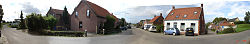
Localización de Kruispolderhaven en Países Bajos
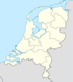
51°21′18″N 4°5′40″E / 51.355, 4.09444Coordenadas: 51°21′18″N 4°5′40″E / 51.355, 4.09444
Entidad Localidad
 • País Bandera de los Países Bajos Países Bajos
 • Provincia Zelanda
 • Municipio Hulst

Kruispolderhaven es una localidad del municipio de Hulst, en la provincia de Zelanda (Países Bajos). Está situada en el Flandes zelandés.

Su nombre proviene del Kruispolder (en neerlandés, pólder en cruz), un pólder ahora inexistente en el estuario del río Escalda.[1] La población nació como puerto del mismo, obtenido por España en 1612.[2]

Referencias

  1. Nova et Accurata Comitatus Zelandiae Tabula, Carel Allard (1648-ca.1730), Zeeuws Archief in de beroemde collectie Zelandia Illustrata (deel 1 inv. nr. 108) van het Koninklijk Zeeuws Genootschap der Wetenschappen, 1691.
  2. M.H. Wilderom, Tussen Afsluitdammen en Deltadijken IV Zeeuwsch Vlaanderen Wilderom, Vlissingen, 1973, pp. 57, 137-138.

Wikimedia foundation. 2010.

Игры ⚽ Поможем написать курсовую

Mira otros diccionarios:

  • Kruispolderhaven — is a rural village located in the eastern Zeeuws Vlaanderen portion of the Dutch province of Zeeland. Its name originates from its location at the eastern tip of the Kruispolder, a crossed polder adjacent to a (now nonexistent) seaport on the… …   Wikipedia

  • Baalhoek — is a hamlet in the Dutch province of Zeeland. VUGA s Alfabetische Plaatsnamengids van Nederland (13th edition), VUGA, 1997.] It is located in the municipality of Hulst, about 5 km east of Kloosterzande on the dyke of the Westerschelde. ANWB… …   Wikipedia

  • Kruisdorp (Zelande) — Kruisdorp (Zélande) Kruisdorp Pays  Pays Bas Commune Hulst Province Zélande Nombre d habitants  ? (?) Code pos …   Wikipédia en Français

  • Kruisdorp (Zélande) — 51° 21′ 57″ N 4° 02′ 21″ E / 51.3658, 4.03917 …   Wikipédia en Français

  • List of places in the Netherlands — This is an alphabetical list of places (cities, towns, villages) in the Netherlands. Lists per province can be found at:* List of towns in Groningen * List of towns in Friesland * List of towns in Drente * List of towns in Overijssel * List of… …   Wikipedia

  • Clinge —   Town   Coat of arms …   Wikipedia

  • Nieuw-Namen —   Town   …   Wikipedia

  • Ossenisse —   Village   Coat of arms …   Wikipedia

  • Clinge — 51°16′14″N 4°5′17″E / 51.27056, 4.08806 …   Wikipédia en Français

  • Flandre Zélandaise — 51°20′N 3°49′E / 51.333, 3.817 …   Wikipédia en Français

Compartir el artículo y extractos

Link directo
Do a right-click on the link above
and select “Copy Link”