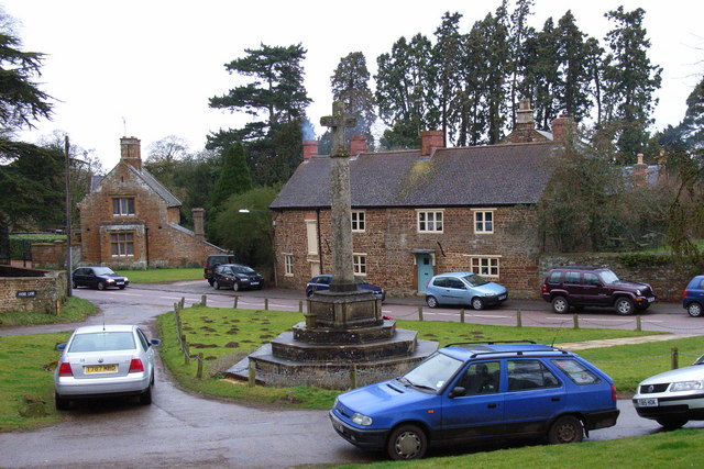
Litchborough

Litchborough
Litchborough
Pueblo y parroquia civil del Reino Unido
Green, war memorial and cottages, Litchborough - geograph.org.uk - 143529.jpg
Litchborough
Litchborough
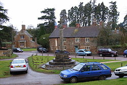
Ubicación en Northamptonshire.
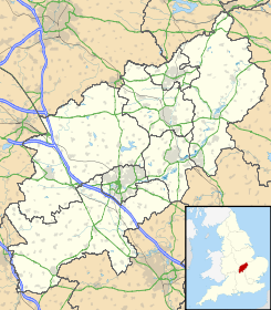
52°11′0.024″N 1°4′33.0414″O / 52.18334, -1.075844833Coordenadas: 52°11′0.024″N 1°4′33.0414″O / 52.18334, -1.075844833
Entidad Pueblo y parroquia civil
 • País Bandera del Reino Unido Reino Unido
 • Nación constitutiva Inglaterra
 • Región Midlands del Este
 • Condado Northamptonshire
 • Distrito South Northamptonshire
Población (2001)  
 • Total 300 hab.
Código postal NN12
Prefijo telefónico 01327

Litchborough es un pueblo y una parroquia civil del distrito de South Northamptonshire, en el condado de Northamptonshire (Inglaterra).

Demografía

Según el censo de 2001,[1] Litchborough tenía 300 habitantes (148 varones y 152 mujeres). 68 de ellos (22,66%) eran menores de 16 años, 218 (72,66%) tenían entre 16 y 74, y 14 (4,66%) eran mayores de 74. La media de edad era de 37,77 años. De los 232 habitantes de 16 o más años, 54 (23,28%) estaban solteros, 155 (66,81%) casados, y 23 (9,91%) divorciados o viudos. 151 habitantes eran económicamente activos, 146 de ellos (96,69%) empleados y otros 5 (3,31%) desempleados. Había 4 hogares sin ocupar, 114 con residentes y 3 eran alojamientos vacacionales o segundas residencias.

Evolución demográfica de Litchborough
1801 1811 1821 1831 1841 1851 1861 1871 1881 1891 1901 1911 1921 1931 1941 1951 1961
302 311 393 415 408 418 - - 348 334 293 258 246 222 - 247 222
(Fuente:Vision of Britain )

Referencias

  1. «Litchborough» (en inglés). Office for National Statistics. Consultado el 5 de julio de 2011.

Wikimedia foundation. 2010.

Игры ⚽ Поможем сделать НИР

Mira otros diccionarios:

  • Microbrewery — Beer barrels outside the Castle Rock microbrewery in Nottingham, England. A microbrewery or craft brewer is a brewery which produces a limited amount of beer, and is associated by consumers with innovation and uniqueness …   Wikipedia

  • Charles Thorneycroft — Personal information Full name Charles Bedford Thorneycroft Born 27 July 1879 Litchborough, Northamptonshire, England Died 31 July 1972 Daventry, Northamptonshire, England Batting style Unknown Bowling style Right arm fast …   Wikipedia

  • Daventry — For other uses, see Daventry (disambiguation). Coordinates: 52°16′N 1°10′W / 52.26°N 1.16°W / 52.26; 1.16 …   Wikipedia

  • South Northamptonshire — For the parliamentary constituency, see South Northamptonshire (UK Parliament constituency). South Northamptonshire Council   District   …   Wikipedia

  • List of places in Northamptonshire — This is a list of places in the ceremonial county of Northamptonshire, United Kingdom. See the list of places in England for places in other counties See also compactTOC NOTOC AAbington Abthorpe Achurch Adstone Alderton Aldwincle Althorp… …   Wikipedia

  • Farthingstone — infobox UK place country = England latitude= 52.11 longitude= 1.06 official name= Farthingstone population = 179 (2001) shire district= Daventry shire county = Northamptonshire region= East Midlands constituency westminster= Daventry post town=… …   Wikipedia

  • List of civil parishes in Northamptonshire — This is a list of civil parishes in Northamptonshire, England. Most parishes have their own parish council, but some smaller parishes may have a parish meeting, or may join together to form a combined parish council. Some larger parishes have… …   Wikipedia

  • Glassy carbon — Glassy carbon, also called vitreous carbon, is a non graphitizing carbon which combines glassy and ceramic properties with those of graphite. The most important properties are high temperature resistance, extreme resistance to chemical attack and …   Wikipedia

  • Adstone — infobox UK place country = England latitude= 52.1586longitude= 1.1293official name= Adstone population = 65 (2001) shire district= South Northamptonshire shire county = Northamptonshire region= East Midlandsconstituency westminster= Daventry post …   Wikipedia

  • Maidford — Coordinates: 52°10′03″N 1°06′31″W / 52.1674°N 1.1087°W / 52.1674; 1.1087 …   Wikipedia

Compartir el artículo y extractos

Link directo
Do a right-click on the link above
and select “Copy Link”