Madhapar

Madhapar
Madhapar
Localidad de la India
Madhapar
Madhapar
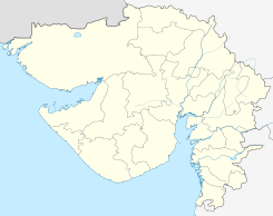
Ubicación de Madhapar en Guyarat.
23°07′39″N 73°36′38″E / 23.1275, 73.61056Coordenadas: 23°07′39″N 73°36′38″E / 23.1275, 73.61056
Entidad Localidad
 • País Bandera de India India
 • Estado Guyarat
 • Distrito Kutch
Altitud  
 • Media 102 msnm
Población (Est.2011[1] )  
 • Total 43.815 hab.
Huso horario IST UTC +5:30
PIN[2] 370020
Código de área 2832

Madhapar es una ciudad de la India en el distrito de Kutch, estado de Guyarat.

Contenido

Geografía

Se encuentra a una altitud de 102 msnm a 140 km de la capital estatal, Gandhinagar, en la zona horaria UTC +5:30.

Demografía

Según estimación 2011 contaba con una población de 43 815 habitantes.[1]

Referencias

Enlaces externos


Wikimedia foundation. 2010.

Игры ⚽ Поможем сделать НИР

Mira otros diccionarios:

  • Madhapar — Infobox Indian Jurisdiction native name = Madhapar latd = 23.14 |longd = 69.42 state name = Gujarat district = Kutch district leader title = leader name = altitude = 3 population as of = 2001 | population total = 25,000 ref|CI1 | population… …   Wikipedia

  • Kutch Gurjar Kashtriya — Kutch Gurjar Kshatriya a.k.a. Mistris of Kutch Total population 51,000[1][2] Regions with significant populations • …   Wikipedia

  • Bhuj — Infobox Indian Jurisdiction native name = Bhuj | type = city | latd = 23.27 | longd = 69.67 locator position = right | state name = Gujarat district = Kachchh leader title = leader name = altitude = 110 population as of = 2001 | population total …   Wikipedia

  • Chandiya —   village   …   Wikipedia

  • Nagor —   village   Coordinates Country India State Gujarat …   Wikipedia

  • Kutch District — Kachchh district કચ્છ જિલ્લો Location of Kachchh district in Gujarat State …   Wikipedia

  • Rajkot — Infobox Indian Jurisdiction type = City type 2 = district, subdistrict native name = Rājkot iucn category = state name = Gujarat skyline = skyline caption = latd = 22.3000 longd = 70.7833 locator position = right base map label = inset map marker …   Wikipedia

  • Nagalpar — Nagalpur   city   …   Wikipedia

  • Devaria, Kachchh — Devaria   village   Coordinates Country India State Gujarat …   Wikipedia

  • Dhaneti — or Dhanetee is village in Bhuj Taluka of Kutch District of Gujarat State of India. It is at a distance of about 26 km from Bhuj the Taluka and District Headquarter of Kutch. Although it is in Bhuj Taluka, the Anjar Taluka headquarter of… …   Wikipedia

Compartir el artículo y extractos

Link directo
Do a right-click on the link above
and select “Copy Link”