Malajkhand

Malajkhand
Malajkhand
Localidad de la India
Malajkhand
Malajkhand
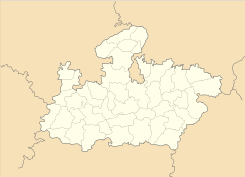
Ubicación de Malajkhand en Madhya Pradesh.
Ubicación de Madhya Pradesh en India.
22°02′59″N 80°42′55″E / 22.04972, 80.71528Coordenadas: 22°02′59″N 80°42′55″E / 22.04972, 80.71528
Entidad Localidad
 • País Bandera de India India
 • Estado Madhya Pradesh
 • Distrito Balaghat
Altitud  
 • Media 581 msnm
Población (Est.2010[1] )  
 • Total 38.011 hab.
Huso horario IST UTC +5:30
PIN[2] 481116
Código de área 7637

Malajkhand es una localidad de la India en el distrito de Balaghat, estado de Madhya Pradesh.

Contenido

Geografía

Se encuentra a una altitud de 581 msnm a 475 km de la capital estatal, Bhopal, en la zona horaria UTC +5:30.

Demografía

Según estimación 2010 contaba con una población de 38 011 habitantes.[1]

Referencias

Enlaces externos


Wikimedia foundation. 2010.

Игры ⚽ Поможем сделать НИР

Mira otros diccionarios:

  • Balaghat — Infobox Indian Jurisdiction native name = Balaghat | type = city | latd = 21.8 | longd = 80.18 locator position = right | state name = Madhya Pradesh district = Balaghat leader title = leader name = altitude = 288 population as of = 2001… …   Wikipedia

  • Balaghat District — a district of Madhya Pradesh state of central India. The town of Balaghat serves as its administrative headquarters.GeographyBalaghat District is located in the southern part of Jabalpur Division. It occupies the south eastern portion of the… …   Wikipedia

  • List of cities and towns in India — This is a list of cities in India whose population is above 20,000. According to Census 2001 data cities and towns are broadly classified as: Class I – Population greater than 100,000 Class II – Population between 80,000 – 99,999 Class III –… …   Wikipedia

Compartir el artículo y extractos

Link directo
Do a right-click on the link above
and select “Copy Link”