Manamadurai

Manamadurai
Manamadurai
Localidad de la India
Manamadurai  மானாமதுரை
Manamadurai
மானாமதுரை
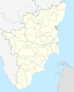
Ubicación de Manamadurai en Tamil Nadu.
Ubicación de Tamil Nadu en India.
9°40′16″N 78°28′15″E / 9.67111, 78.47083Coordenadas: 9°40′16″N 78°28′15″E / 9.67111, 78.47083
Entidad Localidad
 • País Bandera de India India
 • Estado Tamil Nadu
 • Distrito Sivagangai
Altitud  
 • Media 69 msnm
Población (Est.2010[1] )  
 • Total 28.842 hab.
Huso horario IST UTC +5:30
PIN 630 606
Código de área +914574 XX

Manamadurai (en tamil: மானாமதுரை ) es una localidad de la India en el distrito de Sivagangai, estado de Tamil Nadu.

Contenido

Geografía

Se encuentra a una altitud de 69 msnm a 537 km de la capital estatal, Chennai, en la zona horaria UTC +5:30.

Demografía

Según estimación 2010 contaba con una población de 28 842 habitantes.[1]

Referencias

Enlaces externos


Wikimedia foundation. 2010.

Игры ⚽ Нужен реферат?

Mira otros diccionarios:

  • Manamadurai —   city   …   Wikipedia

  • Manamadurai — Original name in latin Manamadurai Name in other language Manamadura, Manamadurai, Mnmadurai State code IN Continent/City Asia/Kolkata longitude 9.67318 latitude 78.47096 altitude 72 Population 27493 Date 2012 02 29 …   Cities with a population over 1000 database

  • Manamadurai taluk — is a taluk of Sivagangai district of the Indian state of Tamil Nadu. The headquarters of the taluk is the town of Manamadurai Population According to the 2001 census, the taluk of Manamadurai had a population of 184,765 with 92,892 males and… …   Wikipedia

  • Manamadurai (State Assembly Constituency) — Manamadurai is a state assembly constituency in Tamil Nadu. It is a Scheduled Caste reserved constituency. It is a component of Ramanathapuram Lok sabha constituency. Elections and winners in the constituency are listed below. Madras State Year… …   Wikipedia

  • Manamadurai block — is a revenue block in the Sivaganga district of Tamil Nadu, India. It has a total of 39 panchayat villages. References Map of revenue blocks of Sivaganga district . Government of Tamil Nadu. http://tnmaps.tn.nic.in/default.htm?blocks.php?dcode=23 …   Wikipedia

  • Sivaganga district — This article is about the district. For its eponymous headquarters, see Sivaganga. Sivaganga District சிவகங்கை மாவட்டம்   district   …   Wikipedia

  • National Highway 226 (India) — 226 …   Wikipedia

  • Highways of Tamil Nadu — Map indicating Highways network of Tamil Nadu In Tamil Nadu, a separate Highways Department (HD) was established on April, 1946 and the same has been renamed as Highways Minor Ports Department (HMPD) on 30 October 2008.[1] HMPD of Tamil Nadu is… …   Wikipedia

  • Ghatam — The ghatam is a percussion instrument, used in the Carnatic music of South India. It is an earthenware pot; the artist uses the fingers, thumbs, palms, and heels of the hands to strike the outer surface of the ghatam. An airy low pitch bass sound …   Wikipedia

  • Chennai Egmore — Coordinates: 13°04′41″N 80°15′42″E / 13.0780°N 80.2616°E / 13.0780; 80.2616 …   Wikipedia

Compartir el artículo y extractos

Link directo
Do a right-click on the link above
and select “Copy Link”