Manavadar

Manavadar
Manavadar
Localidad de la India
Manavadar  માણાવદર
Manavadar
માણાવદર
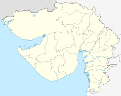
Ubicación de Manavadar en Guyarat.
21°29′43″N 70°08′16″E / 21.49528, 70.13778Coordenadas: 21°29′43″N 70°08′16″E / 21.49528, 70.13778
Entidad Localidad
 • País Bandera de India India
 • Estado Guyarat
 • Distrito Junagadh
Altitud  
 • Media 26 msnm
Población (Est.2011[1] )  
 • Total 30.968 hab.
Huso horario IST UTC +5:30
PIN[2] 362630
Código de área 2874

Manavadar (en guyaratí: માણાવદર ) es una ciudad de la India en el distrito de Junagadh, estado de Guyarat.

Contenido

Geografía

Se encuentra a una altitud de 26 msnm a 392 km de la capital estatal, Gandhinagar, en la zona horaria UTC +5:30.

Demografía

Según estimación 2011 contaba con una población de 30 968 habitantes.[1]

Referencias

Enlaces externos


Wikimedia foundation. 2010.

Игры ⚽ Нужен реферат?

Mira otros diccionarios:

  • Manavadar —   city   …   Wikipedia

  • Manavadar — Manavadar …   Deutsch Wikipedia

  • Manavadar — était un Etat princier (un khanat) des Indes. Lors de l Indépendance la destiné de cet Etat princier fut incertaine : il fut dans un premier temps réuni au Pakistan, puis quelque temps après, à l Inde dont il fait aujourd hui partie (Etat du …   Wikipédia en Français

  • Manavadar — Original name in latin Mnvadar Name in other language Manavadar, Manawadar, Mnvadar State code IN Continent/City Asia/Kolkata longitude 21.49813 latitude 70.13775 altitude 29 Population 29105 Date 2013 02 08 …   Cities with a population over 1000 database

  • Manavadar (Staat) — Flagge von Manavadar Kartenausschnitt aus dem Imperial Gazetteer of India …   Deutsch Wikipedia

  • Bantva Manavadar — was a princely state founded in 1760 on the Kathiawar peninsula in Gujarat, India. It had an area of approximately 574 km², and contained 26 primarily Muslim villages. Upon independence in 1947, the princely states were forced to join either… …   Wikipedia

  • Bantva — Bāntva or Bantwa (بانٹوا) is a small town in Kathiawar, a former district of the state of Gujarat in India. GeographyBantva is located at 21° 28 60N and 70° 4 60E, at an altitude of 20 meters. Nearby towns are Limbuda,Manavadar, Vanthali,… …   Wikipedia

  • Nanadiya —   town   Coordinates Country India State Gujarat …   Wikipedia

  • List of Indian Princely States — Hundreds of princely states in British India existed prior to the independence of India and Pakistan (including the present Bangladesh) in 1947, ruled by semi independent potentates. Only four of the largest of these states were still directed by …   Wikipedia

  • Sardargarh Bantva — Sardargardh Bantva was a princely state founded in 1760 on the Kathiawar peninsula in Gujarat, India. It had an area of approximately 186 km², and contained 13 primarily Muslim villages. Upon independence in 1947, the princely states were forced… …   Wikipedia

Compartir el artículo y extractos

Link directo
Do a right-click on the link above
and select “Copy Link”