Manawar

Manawar
Manawar
Localidad de la India
Manawar
Manawar
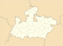
Ubicación de Manawar en Madhya Pradesh.
Ubicación de Madhya Pradesh en India.
22°14′09″N 75°05′17″E / 22.23583, 75.08806Coordenadas: 22°14′09″N 75°05′17″E / 22.23583, 75.08806
Entidad Localidad
 • País Bandera de India India
 • Estado Madhya Pradesh
 • Distrito Dhar
Altitud  
 • Media 194 msnm
Población (Est.2010[1] )  
 • Total 30.375 hab.
Huso horario IST UTC +5:30
PIN[2] 454446

Manawar es una localidad de la India en el distrito de Dhar, estado de Madhya Pradesh.

Contenido

Geografía

Se encuentra a una altitud de 194 msnm a 314 km de la capital estatal, Bhopal, en la zona horaria UTC +5:30.

Demografía

Según estimación 2010 contaba con una población de 30 375 habitantes.[1]

Referencias

Enlaces externos


Wikimedia foundation. 2010.

Игры ⚽ Нужна курсовая?

Mira otros diccionarios:

  • Manawar —   city   …   Wikipedia

  • Manawar — Original name in latin Manwar Name in other language Manawar, Manwar State code IN Continent/City Asia/Kolkata longitude 22.23566 latitude 75.08917 altitude 195 Population 27637 Date 2012 11 08 …   Cities with a population over 1000 database

  • Dhar District — This article is about the district in India. For its eponymous headquarters, see Dhar. for the district of Yemen see Dhar District (Yemen) Dhar district धार जिला …   Wikipedia

  • Dhar — This article is about the municipality in Madhya Pradesh, India. For its namesake district, see Dhar District. This article Dhar, the Indian city. For the Kashmiri caste, see Dhar (surname). Dhar   city   …   Wikipedia

  • Kurree Sharif — is a large village of Gujrat District in the Punjab province of Pakistan. It is located about 45 km north east of Gujrat city and about 25 km from the city of Sialkot. It is perched atop a small hillock which overlooks the Marala Headworks at the …   Wikipedia

  • List of India-related articles — Articles (arranged alphabetically) related to India or Indian culture include: NOTOC List of India related topics People are listed by their first names. 1231 SGM 3 STR 2002 Gujarat violence 2005 in India ( previous years ) 2004 Indian Ocean… …   Wikipedia

  • Mhow — Mhow …   Wikipedia

  • Bannu District — Infobox Pakistan district district = Bannu District area = 1227 population = 677,346 pop year = density = 552 caption = Location of Bannu District (highlighted in red) within the North West Frontier Province. region = North West Frontier Province …   Wikipedia

  • Maheshwar — महेश्वर   town   …   Wikipedia

  • Mandleshwar —   city   …   Wikipedia

Compartir el artículo y extractos

Link directo
Do a right-click on the link above
and select “Copy Link”