Mandsaur

Mandsaur
Mandsaur
Localidad de la India
Mandsaur  मंदसौर
Mandsaur
मंदसौर
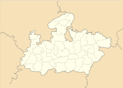
Ubicación de Mandsaur en Madhya Pradesh.
Ubicación de Madhya Pradesh en India.
24°04′13″N 75°04′08″E / 24.07028, 75.06889Coordenadas: 24°04′13″N 75°04′08″E / 24.07028, 75.06889
Entidad Localidad
 • País Bandera de India India
 • Estado Madhya Pradesh
 • Distrito Mandsaur
Altitud  
 • Media 440 msnm
Población (Est.2010[1] )  
 • Total 135.196 hab.
Huso horario IST UTC +5:30
PIN[2] 458001
Código de área 7422

Mandsaur (en hindi: मंदसौर ) es una localidad de la India, centro administrativo del distrito de Mandsaur en el estado de Madhya Pradesh.

Contenido

Geografía

Se encuentra a una altitud de 440 msnm a 334 km de la capital estatal, Bhopal, en la zona horaria UTC +5:30.

Demografía

Según estimación 2010 contaba con una población de 135 196 habitantes.[1]

Referencias

Enlaces externos


Wikimedia foundation. 2010.

Игры ⚽ Поможем написать курсовую

Mira otros diccionarios:

  • Mandsaur — This article is about the municipality in Madhya Pradesh, India. For its namesake district, see Mandsaur District. Mandsaur   city   …   Wikipedia

  • Mandsaur — ▪ India also spelled  Mandasor        city, northwestern Madhya Pradesh state, west central India. The city lies along the Sau River, a tributary of the Chambal (Chambal River). Mandsaur is of considerable antiquity. Just to the southeast lie… …   Universalium

  • Mandsaur — Original name in latin Mandsaur Name in other language Mandasor, Mandsaur State code IN Continent/City Asia/Kolkata longitude 24.07184 latitude 75.06986 altitude 440 Population 124988 Date 2012 09 06 …   Cities with a population over 1000 database

  • Mandsaur — Admin ASC 2 Code Orig. name Mandsaur Country and Admin Code IN.35.1263835 IN …   World countries Adminstrative division ASC I-II

  • Mandsaur Fort — Mandsaur or Dashpur Fort Mandsaur Fort, also known as Dashpur Fort, is situated in Mandsaur city in Mandsaur district in Madhya Pradesh state of India. [1] The Mandsaur city is situated on the border of Malwa and Mewar and as such was strate …   Wikipedia

  • Mandsaur (Lok Sabha constituency) — Mandsaur Lok Sabha constituency (Hindi: मंदसौर लोक सभा निर्वाचन क्षेत्र) is one of the 29 Lok Sabha constituencies in Madhya Pradesh state in central India. This constituency covers the entire Mandsaur and Neemuch districts and part of Ratlam… …   Wikipedia

  • Mandsaur Institute of Technology — (MIT) is an engineering college in the city of Mandsaur in the state of Madhya Pradesh, India. It was established in 1996. It is affiliated to Rajiv Gandhi Proudyogiki Vishwavidyalaya, Bhopal, which is the university of technology of the state of …   Wikipedia

  • Mandsaur District — This article is about the district. For its eponymous headquarters, see Mandsaur. Mandsaur district मंदसौर जिला …   Wikipedia

  • Narayangarh, Mandsaur — For othwer places with the same name, see Narayangarh (disambiguation). Narayangarh   city   …   Wikipedia

  • Navali Mandsaur — Navali (नावली)is a village in Bhanpura tahsil in Mandsaur district, Madhya Pradesh. Navali derives name from Latin word Navalis meaning pertaining to ship . History Main article: Taxakeshwar Taxakeshwar (तक्षकेश्वर) or Takhaji (ताखाजी) is a place …   Wikipedia

Compartir el artículo y extractos

Link directo
Do a right-click on the link above
and select “Copy Link”