- Motutapu
-
Motutapu 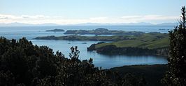
Localización País  Nueva Zelanda
Golfo Golfo de Hauraki Coordenadas Geografía Superficie 15,09 km² Punto más alto 121 m Demografía Población 75 Densidad 5 hab./km² Otros datos Organismo administrador Department of Conservation (NZ)
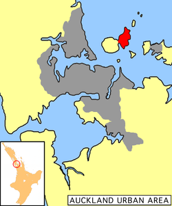
Motutapu es una isla de Nueva Zelanda localizada en el Golfo de Hauraki y adyacente a la isla Rangitoto que surgió durante una erupción volcánica probablemente ocurrida entre los siglos XIII y XIV. Motutapu forma parte del Parque marìtimo del Golfo de Hauraki y en la isla se ha establecido una reserva natural llamada Reserva recreativa Isla Motutapu.
La isla estuvo habitada por tribus maoríes durante varios siglos e inclusive hasta el tiempo de la erupción que originó Rangitoto. Ellos llamaban a la isla Te Motutapu a Taikehu, la isla sagrada de Taikehu. En la actualidad existe un gran número de sitios arqueológicos en Motutapu con vestigios de la ocupación maorí.
Durante la Segunda guerra mundial, en Motutapu se estableció una base de operaciones que albergaba alrededor de mil efectivos. Algunas de las instalaciones construídas durante la guerra aún se conservan al día de hoy.[1]
Referencias
- ↑ http://www.doc.govt.nz/conservation/historic/by-region/auckland/hauraki-gulf-islands/motutapu-island-recreation-reserve/ Historic Motutapu Island (en inglés)
Categorías:- Archipiélagos e islas de Nueva Zelanda
- Región de Auckland

Wikimedia foundation. 2010.