Ormesby St. Michael

Ormesby St. Michael
Ormesby St. Michael
Pueblo y parroquia civil del Reino Unido
A149, Ormesby St Michael - geograph.org.uk - 772862.jpg
Ormesby St. Michael
Ormesby St. Michael
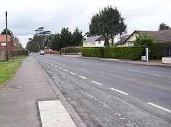
Ubicación en Norfolk.
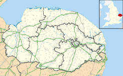
52°40′32.4006″N 1°39′38.3976″E / 52.675666833, 1.660666Coordenadas: 52°40′32.4006″N 1°39′38.3976″E / 52.675666833, 1.660666
Entidad Pueblo y parroquia civil
 • País Bandera del Reino Unido Reino Unido
 • Nación constitutiva Inglaterra
 • Región Este de Inglaterra
 • Condado Norfolk
 • Distrito Great Yarmouth
Población (2001)  
 • Total 297 hab.
Código postal NR29

Ormesby St. Michael es un pueblo y una parroquia civil del distrito de Great Yarmouth, en el condado de Norfolk (Inglaterra).

Demografía

Según el censo de 2001,[1] Ormesby St. Michael tenía 297 habitantes (149 varones y 148 mujeres). 38 de ellos (12,79%) eran menores de 16 años, 244 (82,16%) tenían entre 16 y 74, y 15 (5,05%) eran mayores de 74. La media de edad era de 45,17 años. De los 259 habitantes de 16 o más años, 54 (20,85%) estaban solteros, 171 (66,02%) casados, y 34 (13,13%) divorciados o viudos. 154 habitantes eran económicamente activos, 148 de ellos (96,1%) empleados y 6 (3,9%) desempleados. Había 128 hogares con residentes y ninguno sin ocupar.

Evolución demográfica de Ormesby St. Michael
1801 1811 1821 1831 1841 1851 1861 1871 1881 1891 1901 1911 1921 1931 1941 1951 1961
219 242 261 273 278 294 - - 287 336 287 300 291 320 - 294 321
(Fuente:Vision of Britain )

Referencias

  1. «Ormesby St. Michael» (en inglés). Office for National Statistics. Consultado el 22 de julio de 2011.

Enlaces externos


Wikimedia foundation. 2010.

Игры ⚽ Нужно решить контрольную?

Mira otros diccionarios:

  • Ormesby St. Michael — is a small village and civil parish in the English county of Norfolk. It is situated some 12 km north west of the town of Great Yarmouth and 25 km east of the city of Norwich. Nearby are Ormesby Broad and Ormesby Little Broad, both part of the… …   Wikipedia

  • Ormesby St Michael — Coordinates: 52°40′31″N 1°39′35″E / 52.67523°N 1.65966°E / 52.67523; 1.65966 …   Wikipedia

  • Ormesby St. Margaret with Scratby — is a civil parish in the English county of Norfolk. It is made up of the inland village of Ormesby St. Margaret and the adjacent seaside resorts of Scratby and California. The villages are some 2 km apart, and they are situated about 10 km north… …   Wikipedia

  • Ormesby St Margaret with Scratby — Coordinates: 52°40′29″N 1°41′51″E / 52.674613°N 1.697474°E / 52.674613; 1.697474 …   Wikipedia

  • Saint Michael (disambiguation) — Saint Michael or Saint Michaels may refer to:* Michael (archangel), the Biblical archangel for whom the other St. Michaels are named * The Order of Saint Michael, a French chivalric order * The Order of St Michael and St George, a British… …   Wikipedia

  • Saint Michael — (en inglés: San Miguel), con abreviación St. Michael, es un topónimo muy difundido que puede referirse a: Contenido 1 Toponimia 1.1 Divisiones administrativas 1.1.1 En Reino Unido 1.1.2 …   Wikipedia Español

  • Great Yarmouth (borough) — The Borough of Great Yarmouth is a local government district with borough status in Norfolk, England. It is named after its main town, Great Yarmouth.HistoryThe borough was formed on April 1, 1974, under the Local Government Act 1972, as a merger …   Wikipedia

  • Burgh Castle — Coordinates: 52°35′08″N 1°39′13″E / 52.58547°N 1.65365°E / 52.58547; 1.65365 …   Wikipedia

  • Martham — Coordinates: 52°42′30″N 1°37′58″E / 52.70844°N 1.63282°E / 52.70844; 1.63282 …   Wikipedia

  • List of places in Norfolk — This is a list of cities, towns and villages in the ceremonial and shire county of Norfolk, England. See the list of places in England for places in other counties. Contents Top 0–9 A B C D E F G H I J K L M N O P Q R S T U V W X Y Z NOTOC A*Acle …   Wikipedia

Compartir el artículo y extractos

Link directo
Do a right-click on the link above
and select “Copy Link”