South Cambridgeshire

South Cambridgeshire
Distrito del Reino Unido
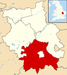
South Cambridgeshire UK locator map.svg
Ubicación en el condado de Cambridgeshire.
Entidad Distrito
 • País Bandera del Reino Unido Reino Unido
 • Nación constitutiva Inglaterra
 • Región Este de Inglaterra
 • Condado Cambridgeshire
Superficie  
 • Total 901.63 km²
Población (2001)  
 • Total 130 108 hab.
 • Densidad 144,3 hab/km²

South Cambridgeshire es un distrito no metropolitano del condado de Cambridgeshire (Inglaterra). Tiene una superficie de 901,63 km². Según el censo de 2001, South Cambridgeshire estaba habitado por 130 108 personas y su densidad de población era de 144,3 hab/km².[1]

Referencias

  1. «Find statistics for an area» (en inglés). Office for National Statistics. Consultado el 12 de agosto de 2011.

Wikimedia foundation. 2010.

Игры ⚽ Поможем сделать НИР

Mira otros diccionarios:

  • South Cambridgeshire — District Lage in Cambridgeshire Status District Region East of England Verw.grafschaft Cambridgeshire …   Deutsch Wikipedia

  • South Cambridgeshire — is a mostly rural local government district of Cambridgeshire, England. It was formed on 1 April 1974 by the merger of Chesterton Rural District and South Cambridgeshire Rural District. It surrounds the city of Cambridge, which is administered… …   Wikipedia

  • South Cambridgeshire — ▪ district, England, United Kingdom       district, administrative county of Cambridgeshire, east central England. The district lies almost entirely within the historic county of Cambridgeshire, except for the area around Great Chishill, which… …   Universalium

  • South Cambridgeshire Rural District — South Cambridgeshire was a rural district in Cambridgeshire, England from 1934 to 1974.It was formed in 1934 under a County Review Order. It was formed by merger of Linton Rural District and Melbourn Rural District and part of Caxton and… …   Wikipedia

  • South Cambridgeshire local elections — One third of South Cambridgeshire District Council is elected each year, followed by one year without election.Political controlIndependent 1973 1992No overall control 1992 2007Conservative 2007 presentCouncil elections*South Cambridgeshire… …   Wikipedia

  • South Cambridgeshire (UK Parliament constituency) — UK constituency infobox Name = South Cambridgeshire Map1 = SouthCambridgeshire Map2 = Cambridgeshire Type = County Year = 1997 Entity = Cambridgeshire County = Cambridgeshire EP = East of England MP = Andrew Lansley Party = ConservativeSouth… …   Wikipedia

  • Conington, South Cambridgeshire — Not to be confused with Conington, Huntingdonshire. Coordinates: 52°16′39″N 0°03′57″W / 52.277522°N 0.065704°W / …   Wikipedia

  • Newton, South Cambridgeshire — Coordinates: 52°07′29″N 0°05′57″E / 52.12474°N 0.09924°E / 52.12474; 0.09924 …   Wikipedia

  • Cambridgeshire Constabulary — Logo of the Cambridgeshire Constabulary. Agency overview Formed 1851, 1965 (merger) …   Wikipedia

  • South West Norfolk (UK Parliament constituency) — South West Norfolk County constituency for the House of Commons Boundary of South West Norfolk in Norfolk …   Wikipedia

Compartir el artículo y extractos

Link directo
Do a right-click on the link above
and select “Copy Link”