South Hams — District Lage in Devon Status District Region South West England Verw.grafschaft Devon … Deutsch Wikipedia
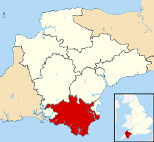
South Hams — is a local government district on the south coast of Devon, England. It contains the towns of Dartmouth, Kingsbridge, Ivybridge, Salcombe, and Totnes, where the district council has its offices.To the north it includes part of Dartmoor National… … Wikipedia
South Hams — 50° 25′ 53″ N 3° 41′ 28″ W / 50.43138889, 3.69111111 … Wikipédia en Français
South Hams — ▪ district, England, United Kingdom southernmost district in the administrative and historic county of Devon, southwest England. It extends from Dartmoor in the north to the English Channel in the south. Its scenery and rural character… … Universalium
South Hams local elections — South Hams Council is elected every four years.Political controlIndependent 1973 1983No overall control 1983 1987Conservative 1987 1995No overall control 1995 1999Conservative 1999 presentCouncil electionsSouth Hams Council election 1999South… … Wikipedia
South Hams Radio — Radio station name = South Hams Radio airdate = December 1 1999 frequency = 100.5 MHz, 100.8 MHz, 101.2 MHz, 101.9 MHz share = 8.8% share as of = March 2008 share source = [http://www.rajar.co.uk/listening/quarterly listening.php] area = South… … Wikipedia
South Hams (UK Parliament constituency) — UK former constituency infobox Name = South Hams Type = County Year = 1983 Abolition = 1997 members = oneSouth Hams was a county constituency based on the South Hams district of Devon. It returned one Member of Parliament to the House of Commons… … Wikipedia
Ashford, South Hams — infobox UK place country = England static static image caption= latitude= 50.31 longitude= 03.85 official name =Ashford, South Hams population = shire district= shire county= Devon region= South West England constituency westminster= post town=… … Wikipedia
Bickleigh, South Hams — Bickleigh is a small village on the southern edge of Dartmoor in Devon, England. It has a population of roughly 50 people. It is in the South Hams district, and is about seven miles north of Plymouth city centre.In the village is a 500 year old… … Wikipedia
South West Coast Path — The starting point at Minehead Length 630 miles (1,014 km) Location England: Somerset, Devon, Cornwall … Wikipedia
 Reino Unido