Springville (Virginia)

Springville (Virginia)
Springville, Virginia
Lugar designado por el censo de los Estados Unidos
Springville
Springville
Ubicación de Springville en el condado de Tazewell, Virginia.
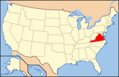
Ubicación de Virginia en EE. UU.
37°11′56″N 81°23′46″O / 37.19889, -81.39611Coordenadas: 37°11′56″N 81°23′46″O / 37.19889, -81.39611
Entidad Lugar designado por el censo
 • País Bandera de los Estados Unidos Estados Unidos
 • Estado Bandera de Virginia Virginia
 • Condado Tazewell
Superficie  
 • Total 19.33 km²
Altitud  
 • Media 830[1] msnm
Población (2010)  
 • Total 1.371 hab.
 • Densidad 70,92 hab/km²
Código ZIP 24630
Código de área 276

Springville es un lugar designado por el censo situado en el condado de Tazewell, Virginia (Estados Unidos). Según el censo de 2010 tenía una población de 1.371 habitantes.[2] [3]

Demografía

Según el censo de 2010, Springville tenía una población en la que el 97,3% eran blancos; el 0,6% afroamericanos; el 0,3% eran indios americanos y nativos de Alaska; el 0,1% eran asiáticos; el 0,0% hawaianos y otros isleños del Pacífico; el 0,4% de otra raza, y el 1,3% a partir de dos o más razas. El 0,7% del total de la población eran hispanos o latinos de cualquier raza.[4]

Referencias

  1. «Geographic Names Information System» (en inglés). Servicio Geológico de los Estados Unidos. Consultado el 11 de julio de 2011.
  2. «Encuentra un condado» (en inglés). Asociación Nacional de Condados (11 de julio de 2011). Consultado el 11 de julio de 2011.
  3. Oficina del Censo de los Estados Unidos (ed.): «U.S. Gazetteer: 2000 and 1990». Consultado el 10/07/2008.
  4. «U.S. Gazetteer: Censo de 2010» (en inglés). Oficina del Censo de los Estados Unidos (16 de febrero de 2011). Consultado el 11 de julio de 2011.


Enlaces externos


Wikimedia foundation. 2010.

Игры ⚽ Поможем написать курсовую

Mira otros diccionarios:

  • Springville — ist die Bezeichnung mehrerer Orte in den Vereinigten Staaten: Springville (Alabama) Springville (Georgia) Springville (Indiana) Springville (Iowa) Springville (Kalifornien) Springville (New York) Springville (Tennessee) Springville (Utah)… …   Deutsch Wikipedia

  • Virginia Vallejo — Virginia Vallejo, Colombian born author, [http://en.wikipedia.org/wiki/Category:Colombian television presenters television anchorwoman] , celebrity and [http://en.wikipedia.org/wiki/Category:Colombian socialites socialite] who lost her career… …   Wikipedia

  • Tazewell, Virginia — Town of Tazewell, Virginia   Town   Seal …   Wikipedia

  • North Tazewell, Virginia —   Neighborhood   …   Wikipedia

  • Tazewell County (Virginia) — Tazewell County Courthouse Verwaltung US Bundesstaat: Virginia Verwaltungssitz …   Deutsch Wikipedia

  • National Register of Historic Places listings in Tazewell County, Virginia — Map of all coordinates from Google Map of all coordinates from Bing …   Wikipedia

  • Claypool Hill, Virginia —   CDP   Location of Claypool Hill, Virginia …   Wikipedia

  • Tazewell County, Virginia — Infobox U.S. County county = Tazewell County state = Virginia map size = 250 founded = December 20, 1799 seat = Tazewell | area total sq mi =520 area water sq mi =0 area percentage = 0.03% census yr = 2000 pop = 44598 density km2 =15 web =… …   Wikipedia

  • National Register of Historic Places listings in Utah County, Utah — Location of Utah County in Utah This is a list of the National Register of Historic Places listings in Utah County, Utah. This is intended to be a complete list of the properties and districts on the National Register of Historic Places in Utah… …   Wikipedia

  • U.S. Post Office — may refer to the United States Post Office Department (1792–1971) or to the United States Postal Service (since 1971). The term may also refer to individual buildings, many of which have historical or architectural significance. Some noted… …   Wikipedia

Compartir el artículo y extractos

Link directo
Do a right-click on the link above
and select “Copy Link”