Torridge

Torridge
Torridge
Distrito del Reino Unido
Torridge UK locator map.svg
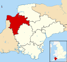
Ubicación en el condado de Devon.
Entidad Distrito
 • País Bandera del Reino Unido Reino Unido
 • Nación constitutiva Inglaterra
 • Región Suroeste de Inglaterra
 • Condado Devon
Superficie  
 • Total 983.84 km²
Población (2001)  
 • Total 58 965 hab.
 • Densidad 59,93 hab/km²

Torridge es un distrito no metropolitano del condado de Devon (Inglaterra). Tiene una superficie de 983,84 km². Según el censo de 2001, Torridge estaba habitado por 58 965 personas y su densidad de población era de 59,93 hab/km².[1]

Referencias

  1. «Find statistics for an area» (en inglés). Office for National Statistics. Consultado el 13 de agosto de 2011.

Wikimedia foundation. 2010.

Игры ⚽ Поможем сделать НИР

Mira otros diccionarios:

  • Torridge — District Lage in Devon Status District Region South West England Verw.grafschaft Devon …   Deutsch Wikipedia

  • Torridge — is a local government district in Devon, England. Its council is based in Bideford. Other towns and villages in the district include Holsworthy, Great Torrington, Hartland and Westward Ho!. The Island of Lundy is administratively part of the… …   Wikipedia

  • Torridge — ▪ district, England, United Kingdom       district in the northwestern part of the administrative and historic county of Devon, southwestern England, with its eastern boundary at the mouth of the River Torridge, the site of its main town,… …   Universalium

  • Torridge — 50° 53′ 35″ N 4° 15′ 54″ W / 50.893, 4.265 …   Wikipédia en Français

  • Torridge and West Devon (UK Parliament constituency) — Coordinates: 50°42′54″N 4°15′47″W / 50.715°N 4.263°W / 50.715; 4.263 …   Wikipedia

  • River Torridge — The River Torridge is a river in Devon in England. It was the home of Tarka the Otter in Henry Williamson s book. The Torridge local government district is named after the river.The river rises close to the border with Cornwall (north of the… …   Wikipedia

  • Woolfardisworthy, Torridge — Woolfardisworthy is a village in the Torridge district in the English county of Devon.The name of the village is a local curiosity, as its pronunciation (and occasional spelling) differs to how one may try to pronounce it. On local signs, the… …   Wikipedia

  • Bideford — infobox UK place country = England static official name= Bideford latitude= 51.0162 longitude= 4.2171 population = 14,599 (2001 est.) [ [http://www.devon.gov.uk/dris/demog/tr aa01.html devon.gov.uk] ] shire district= Torridge shire county = Devon …   Wikipedia

  • Northam, Devon — Coordinates: 51°02′21″N 4°12′37″W / 51.0393°N 4.2104°W / 51.0393; 4.2104 …   Wikipedia

  • Bideford — 51°0′58″N 4°13′1″O / 51.01611, 4.21694 Bideford est une petite ville et aussi un port sur l estuaire de la rivière Torri …   Wikipédia en Français

Compartir el artículo y extractos

Link directo
Do a right-click on the link above
and select “Copy Link”