U.S. Route 183

U.S. Route 183
US 183.svg
Ruta Federal 183
Bandera de los Estados Unidos Estados Unidos
US 183 map.png
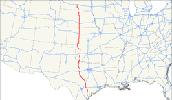
Tipo Red de Carreteras Federales de Estados Unidos
Longitud 1250 mi (2012 km)[1]
Orientación Norte a Sur
 • Norte I-90.svg en Presno, SD
 • Sur US 77.svg US 77 en Refugio, TX
Cruces

I-10.svgI-10 en Luling, TX
I-35.svgI-35 en Austin, TX
I-20.svgI-25 en Cisco, TX
I-40.svgI-40 en Clinton, OK
I-70.svgI-70 en Hays, KS

I-80.svgI-80 en Elm Creek, NE
Cierre 1930

La U.S. Route 183 es una carretera federal de sentido norte–sur. La Ruta 183 fue la última ruta del sistema en ser completada y pavimentada. El segmento de 20 millas (32 km) en el condado de Loup, Nebraska al norte de Taylor, estuvo sin pavimentar hasta 1967.[2] El extremo norte de la carretera se encuentra en Preshno, Dakota del Sur en la intersección con la Interestatal 90. Su extremo sur se encuentra en Refugio, Texas, en la intersección sur con la U.S. Highway 77 y alterna U.S. 77. US 183 y Alt US 77 con conexiones a 80 millas (129 km) entre Cuero y Refugio.

Véase también

Rutas relacionadas

Referencias


Wikimedia foundation. 2010.

Игры ⚽ Нужен реферат?

Mira otros diccionarios:

  • Route 183 (Japan) — Infobox road state=Japan type=National route=183 maint= name notes= 国道183号 length km=196.4 length round= length ref= established= direction a= terminus a= junction= direction b= terminus b= browse= commons=category customcommons=Route 183… …   Wikipedia

  • New Jersey Route 183 — Route 183 Route information …   Wikipedia

  • U.S. Route 183 — Infobox U.S. Route article route=183 length mi=1250 length round=0 length ref=cite web|last=Droz|first=Robert V|url=http://www.us highways.com/usbt.htm|title=U.S. Highways: From US 1 to (US 830)|accessdate=2007 07 06] yrcom=1930 direction a=South …   Wikipedia

  • London Buses route 183 — Infobox London Bus number=183 ibus=yes operator=Transdev London garage=Edgware vehicle=Volvo B7TL 10.6m / Plaxton President pvr=15 start=Pinner via=Harrow Kenton Kingsbury Hendon end=Golders Green length=11 miles (17 km) level=Daily… …   Wikipedia

  • Tennessee State Route 183 — Infobox road state=TN type=Secondary route=183 alternate name=Glass Road, Elbridge Obion Road, Old SR 3 maint=TDOT length mi=14.17 length round= length ref= established= direction a=West starting terminus=jct|state=TN|Secondary|21 at Hornbeak, TN …   Wikipedia

  • California State Route 183 — Infobox road state=CA type=SR route=183 section=483 maint=Caltrans length mi=10 length round=0 length ref= [ [http://www.dot.ca.gov/hq/structur/strmaint/brlog2.htm January 1, 2006 California Log of Bridges on State Highways] ] direction a=South… …   Wikipedia

  • Ohio State Route 183 — State Route 183 Route information Maintained by ODOT Length: 43.37 mi[1 …   Wikipedia

  • Virginia State Route 183 — Infobox road state=VA type= route=183 alternate name=Occohannock Neck Road length mi=7.45 length ref=PDFlink| [http://www.virginiadot.org/info/resources/AADT 065 Northampton 2005.pdf 2005 Virginia Department of Transportation Jurisdiction Report… …   Wikipedia

  • Massachusetts Route 183 — Route 183 Route information …   Wikipedia

  • Connecticut Route 183 — Route 183 Route information Maintained by ConnDOT Length: 19.06 mi …   Wikipedia

Compartir el artículo y extractos

Link directo
Do a right-click on the link above
and select “Copy Link”