Umaria

Umaria
Umaria
Localidad de la India
Umaria
Umaria
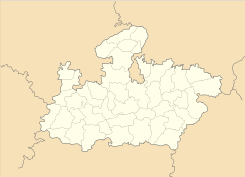
Ubicación de Umaria en Madhya Pradesh.
Ubicación de Madhya Pradesh en India.
23°24′36″N 78°39′31″E / 23.41, 78.65861Coordenadas: 23°24′36″N 78°39′31″E / 23.41, 78.65861
Entidad Localidad
 • País Bandera de India India
 • Estado Madhya Pradesh
 • Distrito Umaria
Altitud  
 • Media 541 msnm
Población (Est.2010[1] )  
 • Total 33.561 hab.
Huso horario IST UTC +5:30
PIN[2] 484661
Código de área 7625

Umaria es una localidad de la India, centro administrativo del distrito de Umaria en el estado de Madhya Pradesh.

Contenido

Geografía

Se encuentra a una altitud de 541 msnm a 447 km de la capital estatal, Bhopal, en la zona horaria UTC +5:30.

Demografía

Según estimación 2010 contaba con una población de 33 561 habitantes.[1]

Referencias

Enlaces externos


Wikimedia foundation. 2010.

Игры ⚽ Нужно решить контрольную?

Mira otros diccionarios:

  • Umaria — Infobox Indian Jurisdiction native name = Umaria | type = city | latd = 23.42 | longd = 78.63 locator position = right | state name = Madhya Pradesh district = Umaria leader title = leader name = altitude = 538 population as of = 2001 population… …   Wikipedia

  • Umaria District — is a district of Madhya Pradesh state in central India. The town of Umaria is the district headquarters. The district is part of Rewa Division. History Umaria was a part of shahdol district. This was separated in 1998. External links *… …   Wikipedia

  • Umaria — Original name in latin Umari Name in other language State code IN Continent/City Asia/Kolkata longitude 23.52684 latitude 80.83745 altitude 465 Population 29740 Date 2012 11 08 …   Cities with a population over 1000 database

  • Pali, Umaria — Infobox Indian Jurisdiction native name = Pali | type = city | latd = 23.35 | longd = 81.05 locator position = right | state name = Madhya Pradesh district = Umaria leader title = leader name = altitude = 450 population as of = 2001 population… …   Wikipedia

  • Birsinghpur — Infobox Indian Jurisdiction native name = Birsinghpur | type = city | latd = 23.22 longd = 81.03 state name = Madhya Pradesh district = Umaria leader title = leader name = altitude = population as of = 2001 population total = 12,334| population… …   Wikipedia

  • Chandia —   city   …   Wikipedia

  • Bandhavgarh National Park — Infobox protected area | name = Bandhavgarh National Park iucn category = II caption = Bengal Tiger in Bandhavgarh Reserve state name = Madhya Pradesh district= Umaria locator x = locator y = location = Madhya Pradesh, India nearest city = Umaria …   Wikipedia

  • Peni Volavola — Captain Ratu Peni Volavola is the Lord Mayor of the Fijian capital of Suva.Volavola, a Councillor representing the Tamavua ward, was elected Lord Mayor in 2003, under a memorandum of understanding between of his United Fiji Party (SDL) and the… …   Wikipedia

  • Nowrozabad (Khodargama) —   city   …   Wikipedia

  • Dindori District — This article is about the district. For its eponymous headquarters, see Dindori. Dindori district दिन्डोरी जिला …   Wikipedia

Compartir el artículo y extractos

Link directo
Do a right-click on the link above
and select “Copy Link”