Umm an Nasan

Umm an Nasan
Isla Umm an Nasan
ام النعسان
King Fahd causeway satellite.png
Localización
País Bandera de Baréin Baréin
Golfo Golfo Pérsico
Coordenadas 26°8′41.17″N 50°24′7.49″E / 26.1447694, 50.4020806Coordenadas: 26°8′41.17″N 50°24′7.49″E / 26.1447694, 50.4020806
Geografía
Demografía
Capital No tiene

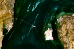
Isla Umm an Nasan[1] (en árabe: ام النعسان) es la cuarta isla más grande en Baréin, después de la isla principal de Baréin, la isla Hawar y la isla de Muharraq. Es una propiedad privada del rey Hamad bin Isa Al Khalifa, y esta fuera del alcance de los ciudadanos comunes. Se conecta a la isla de Bahrein a través de la Calzada del Rey Fahd. Hay poco desarrollo en la isla con excepción de dos palacios para el rey y algunos jardines. También hay una pequeña población de ciervos negros introducidos en la isla.

Umm un Nasan se encuentra en el Golfo de Bahrein al oeste de la isla de Baréin, y al este de la ciudad saudita costera de Khobar.

Véase también

Referencias


Wikimedia foundation. 2010.

Игры ⚽ Нужно сделать НИР?

Mira otros diccionarios:

  • Umm an Nasan — Infobox Islands name = Umm an Nasan image caption = image size = locator Location map|Bahrain|lat=26.144769|long=50.402081 map custom = yes native name = native name link = nickname = location = Persian Gulf coordinates =… …   Wikipedia

  • Île Umm an Nasan — ام النعسان (ar) Image satellite de la chaussée du roi Fahd …   Wikipédia en Français

  • Umm as Sabaan — ام الصبان   Island   …   Wikipedia

  • Umm Nasan — Vorlage:Infobox Insel/Wartung/Bild fehltVorlage:Infobox Insel/Wartung/Fläche fehltVorlage:Infobox Insel/Wartung/Höhe fehlt Umm Nasan أم النعسان Gewässer Golf von Bahrain Inselgruppe Bahrain …   Deutsch Wikipedia

  • Umm Nasan — Ụmm Nasan,   zu Bahrain gehörende Insel im Persischen Golf …   Universal-Lexikon

  • Geography of Bahrain — Map of Bahrain Topography …   Wikipedia

  • Jidda Island — (ArB|جزيرة جدة) is an islet in Bahrain. It lies to the west of Bahrain Island and just north of Umm an Nasan. It is connected to Umm an Nasan by a short causeway.Jidda used to be the location of one of Bahrain s prisons [… …   Wikipedia

  • Geografía de Baréin — Mapa de Baréin. Mapa de relieve. Baréin (de la palabra …   Wikipedia Español

  • Northern Governorate — For the governorate of Lebanon, see North Governorate. Map of Bahrain showing Northern Governorate The Northern Governorate (Arabic: المحافظة الشمالية Al Muhafazah ash Shamaliyah‎) is one of the five governorates of Bahrain. It includes parts of… …   Wikipedia

  • Hawar Islands — The Hawar Islands (Arabic: جزر حوار‎; transliterated: Juzur Ḩawār) are a group of islands situated off the west coast of Qatar in the Gulf of Bahrain of the Persian Gulf. Despite their proximity to Qatar (Suwād al Janūbīyah is only 1.4 km… …   Wikipedia

Compartir el artículo y extractos

Link directo
Do a right-click on the link above
and select “Copy Link”