Vale of White Horse

Vale of White Horse
Vale of White Horse
Distrito del Reino Unido
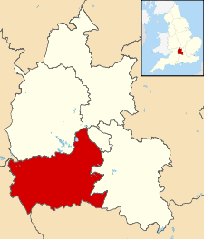
Vale of White Horse UK locator map.svg
Ubicación en el condado de Oxfordshire.
Entidad Distrito
 • País Bandera del Reino Unido Reino Unido
 • Nación constitutiva Inglaterra
 • Región Sudeste de Inglaterra
 • Condado Oxfordshire
Superficie  
 • Total 577.62 km²
Población (2001)  
 • Total 115 627 hab.
 • Densidad 200,18 hab/km²

Vale of White Horse es un distrito no metropolitano del condado de Oxfordshire (Inglaterra). Tiene una superficie de 577,62 km². Según el censo de 2001, Vale of White Horse estaba habitado por 115 627 personas y su densidad de población era de 200,18 hab/km².[1]

Referencias

  1. «Find statistics for an area» (en inglés). Office for National Statistics. Consultado el 12 de agosto de 2011.

Wikimedia foundation. 2010.

Игры ⚽ Нужно сделать НИР?

Mira otros diccionarios:

  • Vale of White Horse — District Lage in Berkshire Status District Region South East England Verw.grafschaft Berks …   Deutsch Wikipedia

  • Vale of White Horse — The Vale of White Horse is a local government district of Oxfordshire in England. The main town is Abingdon, other places include Faringdon and Wantage. There are 68 parishes within the district.It is a geographically distinct region, lying… …   Wikipedia

  • Vale of White Horse — 51° 36′ N 1° 30′ W / 51.6, 1.5 …   Wikipédia en Français

  • Vale of White Horse — Sp Váit Hòrso slėnis Ap Vale of White Horse L D. Britanijoje (Anglijoje) …   Pasaulio vietovardžiai. Internetinė duomenų bazė

  • Vale of White Horse local elections — Vale of White Horse Council is elected every four years.Political controlConservative 1973 1995Liberal Democrat 1995 presentCouncil electionsVale of White Horse Council election, 1999Vale of White Horse Council election, 2003Vale of White Horse… …   Wikipedia

  • Vale of White Horse Council election, 2003 — Elections to Vale of White Horse Council were held on 1st May, 2003. The whole council was up for election with boundary changes having taken place since the last election in 1999. The Liberal Democrats stayed in overall control of the… …   Wikipedia

  • Vale of White Horse Council election, 1999 — Elections to Vale of White Horse Council were held on 6th May, 1999. The whole council was up for election and the Liberal Democrats stayed in overall control.Election ResultElection Summary Party party = Liberal Democrats (UK) seats = 33 gain =… …   Wikipedia

  • Vale of White Horse — ▪ district, England, United Kingdom       district, administrative county of Oxfordshire, historic county of Berkshire, England, lying southwest of Oxford. It encompasses the northern part of the historic county of Berkshire. Its principal… …   Universalium

  • Drayton, Vale of White Horse — Coordinates: 51°38′49″N 1°18′47″W / 51.647°N 1.313°W / 51.647; 1.313 …   Wikipedia

  • Milton, Vale of White Horse — Coordinates: 51°37′37″N 1°17′53″W / 51.627°N 1.298°W / 51.627; 1.298 …   Wikipedia

Compartir el artículo y extractos

Link directo
Do a right-click on the link above
and select “Copy Link”