Valley Ford, California — Infobox Settlement official name = Valley Ford, California other name = Fowlerville pushpin pushpin label position = right pushpin map caption = Location within the state of California subdivision type = Country subdivision name = United States… … Wikipedia
California State Route 1 — For other uses, see CA1 (disambiguation). State Route 1 Route information … Wikipedia
California locations by per capita income — All figures as of the censusGR|2 of 2000 by the United States Census Bureau.California is the thirteenth richest state in the United States of America, with a per capita income of $22,711 (2000). California counties ranked by per capita income… … Wikipedia
Freestone, California — Infobox Settlement official name = Freestone, California imagesize = image caption = The Freestone general store as of 2007. pushpin pushpin label position = right pushpin map caption = Location within the state of California subdivision type =… … Wikipedia
California Trail — Der California Trail war während des 19. Jahrhunderts eine der Hauptrouten für Siedler und Goldsucher aus den Staaten östlich des Missouri River, durch den Mittleren Westen in den Westen der heutigen USA. Der Trail wurde ab den 1840er Jahren von… … Deutsch Wikipedia
Valley City, Ohio — Valley City is an unincorporated community in central Liverpool Township, Medina County, Ohio, United States. The west branch of the Rocky River and Plum Creek flow near Valley City from south to north.It is located at intersection of State… … Wikipedia
California Trail — The California Trail was a major overland emigrant route across the Western United States from Missouri to California in the middle 19th century. It was used by 250,000 farmers and gold seekers to reach the California gold fields and farm… … Wikipedia
California State Route 47 — Infobox road state=CA type=SR route=47 alternate name=Seaside Freeway, Alameda Street section=347 maint=Caltrans and local gov ts length mi=3.078 length round=3 length ref= length notes=(two sections, separated by about 1 mi (2 km), with about 7… … Wikipedia
California's 14th congressional district — Infobox U.S. congressional district state = California district number = 14 representative = Anna Eshoo party = Democratic english area = 1,030 metric area = percent urban = 93.6 percent rural = 6.4 population = 639,088 population year = 2000… … Wikipedia
California's 18th State Senate district — Infobox name = title = California s 18th State Senate district caption = headerstyle = background:#ccf; labelstyle = background:#ddf;header1 = label1 = Registration data1 = 49.9% Republican 33.9% Democratic 11.5% DTS header2 = label2 =… … Wikipedia
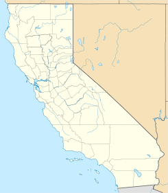
 Valley Ford
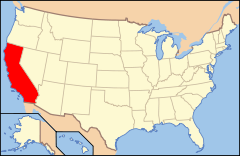
 Estados Unidos
 California
 Portal:California. Contenido relacionado con California.
 Wikimedia Commons alberga contenido multimedia sobre Valley Ford (California). Commons
