Warm Springs (California)
Mira otros diccionarios:
Warm Springs — may refer to: *Warm Mineral Springs, Florida. *Warm Springs Apache, a subdivision of the Chiricahua Apache. *Warm Springs Area, Nevada. *Warm Springs Elementary School, an elementary school in Fremont, California. *Warm Springs, Georgia, location … Wikipedia
Warm Springs Elementary School — Infobox School name = Warm Springs Elementary School motto = Dream it! Believe it! Achieve it! type = Public principal = Brett Nelson, Interim Principal faculty = 32 enrollment = 724 free label = Colors Mascot free text = Navy, Gray Wolf location … Wikipedia
Warm Springs Wilderness — Infobox protected area | name = Warm Springs Wilderness iucn category = Ib caption = locator x = 48 locator y = 108 location = Arizona, USA nearest city = Oatman, Arizona lat degrees = 34 lat minutes = 54 lat seconds = 06 lat direction = N long… … Wikipedia
Warm Springs Area, Nevada — The Warm Springs Area is located near the Moapa Indian Reservation in Clark County, Nevada. The area is a natural oasis in the Mojave Desert. The oasis is fed by a natural warm spring and contains many naturally occurring California Fan Palms,… … Wikipedia
Desert Hot Springs, California — Desert hot springs redirects here. For springs in deserts, see hot springs. City of Desert Hot Springs City … Wikipedia
Harbin Hot Springs, California — Harbin Hot Springs is a non profit hot spring retreat center in Middletown, California, USA that has been a healing and gathering place from the early days of Native American occupation to the present.The baths were commercially developed by… … Wikipedia
California State Route 9 — Infobox road state=CA type=SR route=9 section=309 maint=Caltrans length mi=38.49 length ref= [http://www.dot.ca.gov/hq/structur/strmaint/brlog2.htm January 1, 2006 California Log of Bridges on State Highways] ] length round=2 established=1934… … Wikipedia
California State Route 262 — Infobox road state=CA type=SR route=262 section=562 maint=Caltrans length mi=1.08 length round=2 length ref= [ [http://www.dot.ca.gov/hq/structur/strmaint/brlog2.htm January 1, 2006 California Log of Bridges on State Highways] ] direction a=South … Wikipedia
California State Route 17 — Infobox road state=CA type=SR route=17 section=317 maint=Caltrans length mi=26.49 length ref= [http://www.dot.ca.gov/hq/structur/strmaint/brlog2.htm January 1, 2006 California Log of Bridges on State Highways] ] length round=2 established=1930s… … Wikipedia
California State Route 139 — Infobox road state=CA type=SR route=139 section=439 maint=Caltrans length mi=121.836 length round=3 length ref= length notes=(plus about 21 mi (34 km) on SR 299) history=State highway in ca. 1940 and 1959; numbered by 1946 direction a=South… … Wikipedia
 Warm Springs
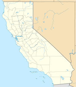
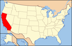
 Estados Unidos
 California
 Portal:California. Contenido relacionado con California.
 Wikimedia Commons alberga contenido multimedia sobre Warm Springs (California). Commons
