Waveney — District Lage in Suffolk Status District Region East of England Verw.grafschaft Suffolk … Deutsch Wikipedia
Waveney — is a local government district in Suffolk, England, named after the River Waveney that forms its north west border. The district council is based in Lowestoft, which is the only unparished area in the district. The other towns in the district are … Wikipedia
Waveney — Waveney, Fluß im südöstlichen England, entspringt in der Nähe der Ousequelle, bildet die Grenze zwischen Norfolk und Suffolk und mündete früher bei Lowestoft in die Nordsee; jetzt vereinigt sich der Hauptarm mit dem Yare. Er ist etwa 80 km lang … Meyers Großes Konversations-Lexikon
Waveney — 52° 28′ 59″ N 1° 45′ 22″ E / 52.4831, 1.7561 … Wikipédia en Français
Waveney — ▪ district, England, United Kingdom district, administrative and historic county of Suffolk, England. It is bounded on the east by the North Sea and on the northwest by the River Waveney. The interior is rich farmland. Along the river are… … Universalium
Waveney — Sp Vevenis Ap Waveney L u. Jungtinėje Karalystėje (Anglijoje) … Pasaulio vietovardžiai. Internetinė duomenų bazė
Waveney Valley Line — The Waveney Valley Line was a branch line covering areas of North Suffolk and South Norfolk in England. The line ran from Tivetshall in Norfolk to Beccles in Suffolk.Beccles station provided a junction with the East Suffolk line, allowing further … Wikipedia
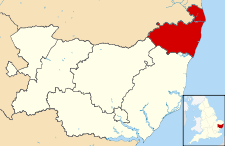
Waveney (UK Parliament constituency) — UK constituency infobox Name = Waveney Map1 = Waveney Map2 = Suffolk Type = County Year = 1983 Entity = Suffolk County = Suffolk EP = East of England MP = Bob Blizzard Party = LabourWaveney is a constituency represented in the House of Commons of … Wikipedia
Waveney, River — ▪ river, England, United Kingdom stream in England whose whole course of 50 miles (80 km) marks the boundary between the East Anglian counties of Norfolk and Suffolk. The river flows northeastward through agricultural countryside, and no… … Universalium
River Waveney — Geobox|River name = Waveney map size = map caption = other name = other name1 = country = England country region type = Counties region = Norfolk region1 = Suffolk city = Diss city1 = Bungay city2 = Beccles length = length imperial = watershed =… … Wikipedia
 Reino Unido