Wayamboweg

Wayamboweg
Wayamboweg
Saramacca resorts.png
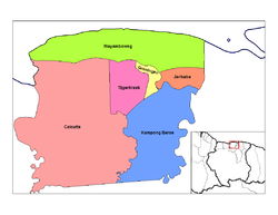
Distrito de Saramacca con Wayamboweg en Rosado oscuro, en el centro
País Surinam Bandera de Surinam
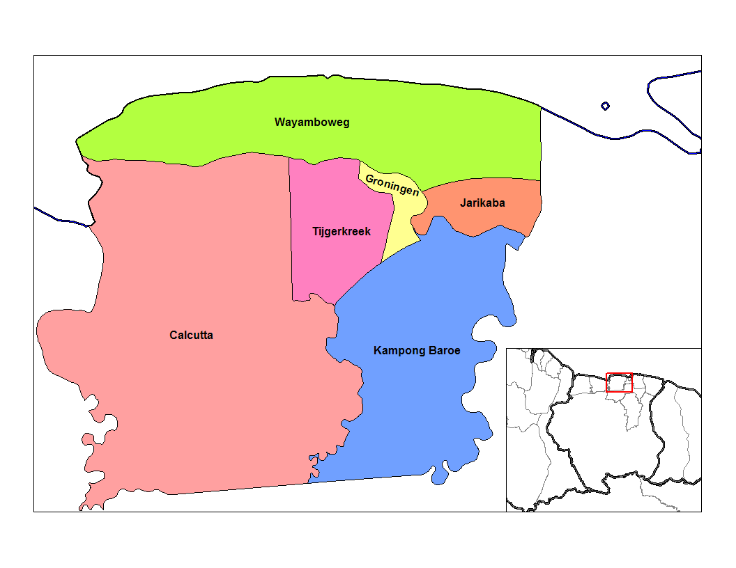
• Distrito Saramacca
• Suburbio Wayamboweg
Población 1,582[1] hab. (2004)
Huso horario UTC-3

Wayamboweg es una de los seis suburbios en los que se divide el distrito de Saramacca, en Surinam.[2] Se ubica en el extremo norte y ocupa toda la costa atlántica del distrito.

Limita al norte con el Océano Atlántico, al oriente con el distrito de Wanica, al sur con los suburbios de Jarikaba, Groningen, Tijgerkreek y Calcutta.

Para el 2004, Wayamboweg según cifras de la Oficina Central de Asuntos Civiles (CBB), tenía 1,582 habitantes.

Referencias

  1. «Datos estadísticos de Wayamboweg en statoids.com» (en inglés). Consultado el 30 de junio de 2010.
  2. Suriname.nu. «Sobre el estado de Saramacca» (en neerlandés). Consultado el 30 de junio de 2010.

Wikimedia foundation. 2010.

Игры ⚽ Поможем сделать НИР

Mira otros diccionarios:

  • Saramacca District — Coordinates: 5°46′57″N 55°37′29″W / 5.7825°N 55.62472°W / 5.7825; 55.62472 …   Wikipedia

  • Saramacca — Saltar a navegación, búsqueda Saramacca Distrito de Surinam Capital Groning …   Wikipedia Español

  • Districts of Suriname — Suriname This article is part of the series: Politics and government of Suriname Constitution President …   Wikipedia

  • Commewijne District — Map of Suriname showing Commewijne district Commewijne is a district of Suriname, located on the right bank of the Suriname River. Commewijne s capital city is Nieuw Amsterdam. Alliance is another major town. The district has a population of… …   Wikipedia

  • Coronie District — Map of Suriname showing Coronie district Coronie is a district of Suriname, situated on the coast. Coronie s capital city is Totness, with other towns including Corneliskondre, Friendship, Jenny. The district border the Atlantic Ocean to the… …   Wikipedia

  • Marowijne District — Map of Suriname showing Marowijne district Marowijne is a district of Suriname, located on the north east coast. Marowijne s capital city is Albina, with other towns including Moengo and Wanhatti. The district borders the Atlantic Ocean to the… …   Wikipedia

  • Nickerie District — Map of Suriname showing Nickerie district Nickerie is a district of Suriname, on the north west coast. Nickerie s capital city is Nieuw Nickerie, the second largest city in the country. Other towns include Washoda and Wageningen. The district… …   Wikipedia

  • Moengo —   Resort   Map showing the resorts of Marowijne District …   Wikipedia

  • Nieuw Amsterdam, Suriname — Nieuw Amsterdam   Resort and town   …   Wikipedia

  • Resorts of Suriname — The districts of Suriname are divided into 62 resorts ( ressorten ). The resorts are listed below, by district:Brokopondo District*Brownsweg *Centrum *Klaaskreek *Kwakoegron *Marshallkreek *SarakreekCommewijne District*Alkmaar *Bakkie *Margaretha …   Wikipedia

Compartir el artículo y extractos

Link directo
Do a right-click on the link above
and select “Copy Link”