West Blocton (Alabama)

West Blocton (Alabama)
West Blocton
Pueblo de los Estados Unidos
Ubicación en el condado de Bibb y en el estado de Alabama Ubicación de Alabama en EE. UU.
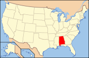
Ubicación en el condado de Bibb y en el estado de Alabama
Map of USA AL.svg
Ubicación de Alabama en EE. UU.
Entidad Pueblo
 • País Bandera de los Estados Unidos Estados Unidos
 • Estado Flag of Alabama.svg Alabama
 • Condado Bibb
Superficie  
 • Total 12,3 km²
 • Tierra 12,2 km²
 • Agua 0,1 km²
Altitud  
 • Media 151 msnm
Población (2010)  
 • Total 1.240 hab.
 • Densidad 100,81 hab/km²
Huso horario Centro: UTC-6
 • en verano UTC-5
Código ZIP 35184
Código de área 205

West Blocton es un pueblo ubicado en el condado de Bibb en el estado estadounidense de Alabama. En el censo de 2000, su población era de 1.372.

Contenido

Demografía

En el 2000[1] la renta per cápita promedia del hogar era de $30,417, y el ingreso promedio para una familia era de $38,854. El ingreso per cápita para la localidad era de $17,861. Los hombres tenían un ingreso per cápita de $31,164 contra $23,000 para las mujeres.

Geografía

West Blocton está situado en 33°7′7″N 87°7′22″O / 33.11861, -87.12278 (33.118733, -87.122875)

Según la Oficina del Censo de los EE.UU., la ciudad tiene un área total de 4.72 millas cuadradas (12.23 km²).

Referencias

  1. «American FactFinder» (en inglés). Oficina del Censo de los Estados Unidos. Consultado el 11 de julio de 2011.

Enlaces externos


Wikimedia foundation. 2010.

Игры ⚽ Поможем написать реферат

Mira otros diccionarios:

  • West Blocton, Alabama — Infobox Settlement official name = West Blocton, Alabama settlement type = Town imagesize = image caption = image imagesize = image caption = image mapsize = 250px map caption = Location in Bibb County and the state of Alabama mapsize1 = map… …   Wikipedia

  • West Blocton — West Blocton, AL U.S. town in Alabama Population (2000): 1372 Housing Units (2000): 599 Land area (2000): 4.702853 sq. miles (12.180333 sq. km) Water area (2000): 0.019974 sq. miles (0.051733 sq. km) Total area (2000): 4.722827 sq. miles… …   StarDict's U.S. Gazetteer Places

  • West Blocton, AL — U.S. town in Alabama Population (2000): 1372 Housing Units (2000): 599 Land area (2000): 4.702853 sq. miles (12.180333 sq. km) Water area (2000): 0.019974 sq. miles (0.051733 sq. km) Total area (2000): 4.722827 sq. miles (12.232066 sq. km) FIPS… …   StarDict's U.S. Gazetteer Places

  • Alabama locations by per capita income — Alabama has the thirty eighth highest per capita income in the United States of America, at $18,189 (2000). Its personal per capita income is $26,338 (2003), the fortieth highest in the country. Its median household income is $34,135 (2000),… …   Wikipedia

  • Alabama Great Southern Railroad — Reporting mark AGS Locale Chattanooga, TN Meridian, MS (New Orleans, LA from 1969) Dates of operation 1877–present Track gauge 4 ft 8 1⁄2 in (1,435 mm) ( …   Wikipedia

  • ALABAMA — ALABAMA, state in the southeastern region of the United States. In 2005 its population was estimated at 4,447,100, with a Jewish population of about 9,000. The largest Jewish communities were birmingham , with approximately 5,300 Jews; Montgomery …   Encyclopedia of Judaism

  • Alabama State Route 69 — Infobox road state=AL type=AL route=69 length mi=259 length ref= [ [http://colepages.com/routes125.html Highway Route Info Routes 1 25 ] ] length round= established= direction a=South direction b=North starting terminus= junction= ending terminus …   Wikipedia

  • Centreville, Alabama — Infobox Settlement official name = Centreville, Alabama settlement type = City imagesize = image caption = image imagesize = image caption = image mapsize = 250px map caption = Location in Bibb County and the state of Alabama mapsize1 = map… …   Wikipedia

  • National Register of Historic Places listings in Alabama — This is a list of buildings, sites, districts, and objects listed on the National Register of Historic Places in Alabama. Contents: Counties in Alabama   (links in italic lead to a new page) Autauga Baldwin Barbour Bibb Blount Bullock Butler …   Wikipedia

  • List of high schools in Alabama — This is a list of high schools in the state of Alabama, United States. Autauga County *Autaugaville School, Autaugaville *Billingsley High School, Billingsley *Prattville High School, Prattville *Marbury High School, Marbury Baldwin County… …   Wikipedia

Compartir el artículo y extractos

Link directo
Do a right-click on the link above
and select “Copy Link”