West Oxfordshire

West Oxfordshire
West Oxfordshire
Distrito del Reino Unido
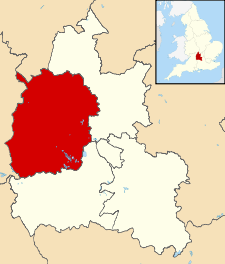
West Oxfordshire UK locator map.svg
Ubicación en el condado de Oxfordshire.
Entidad Distrito
 • País Bandera del Reino Unido Reino Unido
 • Nación constitutiva Inglaterra
 • Región Sudeste de Inglaterra
 • Condado Oxfordshire
Superficie  
 • Total 714.4 km²
Población (2001)  
 • Total 95 640 hab.
 • Densidad 133,87 hab/km²

West Oxfordshire es un distrito no metropolitano del condado de Oxfordshire (Inglaterra). Tiene una superficie de 714,4 km². Según el censo de 2001, West Oxfordshire estaba habitado por 95 640 personas y su densidad de población era de 133,87 hab/km².[1]

Referencias

  1. «Find statistics for an area» (en inglés). Office for National Statistics. Consultado el 12 de agosto de 2011.

Wikimedia foundation. 2010.

Игры ⚽ Нужна курсовая?

Mira otros diccionarios:

  • West Oxfordshire — District Lage in Oxfordshire Status District Region South East England Verw.grafschaft Oxfordshire …   Deutsch Wikipedia

  • West Oxfordshire — is a local government district in north west Oxfordshire, England including towns such as Woodstock, Chipping Norton, Charlbury, and Witney (where the council is based).The area is mainly rural downland and forest, the main activities being… …   Wikipedia

  • West Oxfordshire — ▪ district, England, United Kingdom       district, administrative and historic county of Oxfordshire, south central England, encompassing a mainly rural area in the western part of the county. The Cotswold Hills extend into the northwest, and… …   Universalium

  • Wootton, West Oxfordshire — Wootton is a village in West Oxfordshire, England, located near to the town of Woodstock.To distinguish it from another village of the same name in Oxfordshire – Wootton, Vale of White Horse – it is often referred to as Wootton by Woodstock.The… …   Wikipedia

  • Oxfordshire — Coat of arms of Oxfordshire Flag of Oxfordshire Motto of …   Wikipedia

  • Oxfordshire (UK Parliament constituency) — Oxfordshire Former County constituency for the House of Commons County Oxfordshire 1290 (1290)–1885 …   Wikipedia

  • Oxfordshire County Council elections — Oxfordshire County Council is elected every four years. Contents 1 Political control 2 Council elections 3 By election results 3.1 1997 2001 …   Wikipedia

  • West Berkshire — District Location of West Berkshire in Berkshire Geography Status: Unitary authority Region: South East England …   Wikipedia

  • Oxfordshire — Geografie Status: Zeremonielle und Verwaltungsgrafschaft Region: South East England Fläche: 2.605 km² …   Deutsch Wikipedia

  • Oxfordshire — Condado del Reino Unido …   Wikipedia Español

Compartir el artículo y extractos

Link directo
Do a right-click on the link above
and select “Copy Link”