Wetton (Staffordshire)

Wetton (Staffordshire)
Wetton
Parroquia civil y pueblo del Reino Unido
St Margaret's Church, Wetton - geograph.org.uk - 271524.jpg
Iglesia de Santa Margarita, en Wetton.
Wetton
Wetton
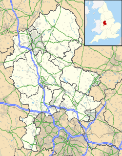
Ubicación de Wetton en Staffordshire.
53°5′41.9″N 1°50′19.2″O / 53.094972, -1.838667Coordenadas: 53°5′41.9″N 1°50′19.2″O / 53.094972, -1.838667
Entidad Parroquia civil y pueblo
 • País Bandera del Reino Unido Reino Unido
 • Nación constitutiva Inglaterra
 • Región Midlands del Oeste
 • Condado Staffordshire
 • Distrito Staffordshire Moorlands
Superficie  
 • Total 9,09 km²
Población (2001)  
 • Total 157 hab.
 • Densidad 17,27 hab/km²
Huso horario GMT (UTC0)
 • en verano BST (UTC +1)
Código postal DE6
Prefijo telefónico 01335

Wetton es una parroquia civil y un pueblo del distrito de Staffordshire Moorlands, en el condado de Staffordshire (Inglaterra).

Contenido

Geografía

Según la Oficina Nacional de Estadística británica, Wetton tiene una superficie de 9,09 km².[1]

Demografía

Según el censo de 2001, Wetton tenía 157 habitantes (47,77% varones, 52,23% mujeres) y una densidad de población de 17,27 hab/km². El 31,21% eran menores de 16 años, el 65,61% tenían entre 16 y 74, y el 3,18% eran mayores de 74. La media de edad era de 33,81 años. Del total de habitantes con 16 o más años, el 30,56% estaban solteros, el 50,93% casados, y el 18,52% divorciados o viudos.[2]

El 96,25% de los habitantes eran originarios del Reino Unido. El resto de países europeos englobaban al 1,88% de la población, mientras que el 1,88% había nacido en cualquier otro lugar. Todos los habitantes eran blancos. El cristianismo era profesado por el 79,62%, mientras que el 12,1% no eran religiosos y el 8,28% no marcaron ninguna opción en el censo.[1]

Había 61 hogares con residentes, 5 vacíos, y 10 eran alojamientos vacacionales o segundas residencias.[2]

Referencias

  1. a b Tablas: «Usual Resident Population (KS01) for Amalgamated Parishes», «Ethnic Group (KS06) for Amalgamated Parishes», «Country of Birth (KS05) for Amalgamated Parishes» y «Religion (KS07) for Amalgamated Parishes», disponibles para descarga aquí. Office for National Statistics (inglés).
  2. a b «Area: Wetton CP (Parish)» (en inglés). Office for National Statistics. Consultado el 15 de noviembre de 2011.

Enlaces externos


Wikimedia foundation. 2010.

Игры ⚽ Поможем написать курсовую

Mira otros diccionarios:

  • Staffordshire Moorlands — is a local government district in Staffordshire, England. Its council, Staffordshire Moorlands District Council, is based in Leek and is located between the city of Stoke on Trent and the Peak District National Park. The 2001 census recorded the… …   Wikipedia

  • Wetton — This article is about the village in Staffordshire. : John Wetton is a bass guitarist and singer songwriter. : Wetton is also a suburb of Cape Town, in the northwestern quadrant of the Cape Flats. Wetton is a small village in the Staffordshire… …   Wikipedia

  • Wetton — This name is of English locational origin from a place thus called in Staffordshire. Recorded as Wettindun in the 1252 Charter of that county and as Wetton in the 1327 Subsidy Rolls the name derives from the Olde English pre 7th Century weta… …   Surnames reference

  • Ilam, Staffordshire — Ilam (pronounced Eye lam ) is a village in the Staffordshire Peak District, lying on the River Manifold. This article describes some of the main features of the village and surroundings. Ilam Village Ilam is best known as the location of the neo… …   Wikipedia

  • List of civil parishes in Staffordshire — This is a list of civil parishes in Staffordshire, England. Stoke on Trent is included in this list (though it is entirely unparished). =Cannock Chase= Cannock is unparished.* Brereton and Ravenhill * Bridgtown * Brindley Heath * Cannock Wood *… …   Wikipedia

  • Long Low, Wetton — Long Low is a Neolithic and Bronze Age site in the English county of Staffordshire. It is about 2 km SE of Wetton (gbmapping|SK122539).It consists of two round cairns linked by a connecting bank an unusual layout and one that is unique in England …   Wikipedia

  • Сэр Гавейн и Зелёный Рыцарь — Sir Gawain and the Green Knight …   Википедия

  • Leek and Manifold Valley Light Railway — Infobox rail railroad name=Leek and Manifold Valley Light Railway gauge=RailGauge|30 start year=1904 end year=1934 length=8 frac14; miles hq city=Leek locale=England successor=AbandonedThe Leek and Manifold Valley Light Railway (L MVLR) was a… …   Wikipedia

  • Dovedale — Coordinates: 53°03′35″N 1°46′36″W / 53.0597°N 1.7767°W / 53.0597; 1.7767 …   Wikipedia

  • Manifold Way — Thor s Cave, viewed from the Manifold Way A typical view lookin …   Wikipedia

Compartir el artículo y extractos

Link directo
Do a right-click on the link above
and select “Copy Link”