Whitgreave

Whitgreave
Whitgreave
Parroquia civil y pueblo del Reino Unido
Whitgreave
Whitgreave
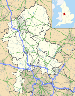
Ubicación de Whitgreave en Staffordshire.
52°51′4.1″N 2°8′59″O / 52.851139, -2.14972Coordenadas: 52°51′4.1″N 2°8′59″O / 52.851139, -2.14972
Entidad Parroquia civil y pueblo
 • País Bandera del Reino Unido Reino Unido
 • Nación constitutiva Inglaterra
 • Región Midlands del Oeste
 • Condado Staffordshire
 • Distrito Stafford
Superficie  
 • Total 5,23 km²
Población (2001)  
 • Total 188 hab.
 • Densidad 35,95 hab/km²
Huso horario GMT (UTC0)
 • en verano BST (UTC +1)
Código postal ST18

Whitgreave es una parroquia civil y un pueblo del distrito de Stafford, en el condado de Staffordshire (Inglaterra).

Contenido

Geografía

Según la Oficina Nacional de Estadística británica, Whitgreave tiene una superficie de 5,23 km².[1]

Demografía

Según el censo de 2001, Whitgreave tenía 188 habitantes (47,87% varones, 52,13% mujeres) y una densidad de población de 35,95 hab/km². El 23,4% eran menores de 16 años, el 75% tenían entre 16 y 74, y el 1,6% eran mayores de 74. La media de edad era de 35,45 años. Del total de habitantes con 16 o más años, el 27,78% estaban solteros, el 65,97% casados, y el 6,25% divorciados o viudos.[2]

Todos los habitantes eran blancos. La mayor parte (97,88%) eran originarios del Reino Unido y el resto (2,12%) de los países europeos. El cristianismo era profesado por el 81,91%, mientras que el 11,7% no eran religiosos y el 6,38% no marcaron ninguna opción en el censo.[1]

Había 70 hogares con residentes, 5 vacíos, y 3 eran alojamientos vacacionales o segundas residencias.[2]

Referencias

  1. a b Tablas: «Usual Resident Population (KS01) for Amalgamated Parishes», «Ethnic Group (KS06) for Amalgamated Parishes», «Country of Birth (KS05) for Amalgamated Parishes» y «Religion (KS07) for Amalgamated Parishes», disponibles para descarga aquí. Office for National Statistics (inglés).
  2. a b «Area: Whitgreave CP (Parish)» (en inglés). Office for National Statistics. Consultado el 20 de octubre de 2011.

Enlaces externos


Wikimedia foundation. 2010.

Игры ⚽ Поможем написать реферат

Mira otros diccionarios:

  • Whitgreave — is a very small village a few miles to the NNW of Stafford situated mid way between the M6 motorway to the west and the A34 trunk road to the east.It lies about 1.5 miles to the northeast of Great Bridgeford. The small 19th century village church …   Wikipedia

  • Escape of Charles II — The Escape of Charles II from England in 1651 is a key episode in his life. Although it took only six weeks, it had a major effect on his attitudes for the rest of his life.The fugitive kingCharles had lost to Cromwell s New Model Army at the… …   Wikipedia

  • John Huddleston — Father John Huddleston (15 April, 1608 – buried 13 September, 1698) was a monk of the Order of St. Benedict who helped Charles II during his escape and was present when Charles converted to the Catholic faith on his deathbed. Early life and… …   Wikipedia

  • Huddleston, John — • Monk of the Order of St. Benedict; b. at Farington Hall, Lancashire, 15 April, 1608; exact date of death unknown; buried at London, 13 September, 1698 Catholic Encyclopedia. Kevin Knight. 2006. Huddleston, John      …   Catholic encyclopedia

  • John Huddleston —     John Huddleston     † Catholic Encyclopedia ► John Huddleston     Monk of the Order of St. Benedict; b. at Farington Hall, Lancashire, 15 April, 1608; exact date of death unknown; buried at London, 13 September, 1698. He was the second son of …   Catholic encyclopedia

  • Moseley Old Hall — For the hall in Cheadle, Greater Manchester, see Moseley Old Hall, Cheadle. Moseley Old Hall, July 2006 Moseley Old Hall is a National Trust property located in Fordhouses, north of Wolverhampton in the United Kingdom. It is famous as one of the… …   Wikipedia

  • Featherstone, Staffordshire — Infobox UK place country = England official name= Featherstone latitude= 52.64347 longitude= 2.09349 population = 3,870 (2004 Estimate) shire district= South Staffordshire region= West Midlands shire county = Staffordshire constituency… …   Wikipedia

  • Stafford Grammar School — Infobox UK school name = Stafford Grammar School size = latitude = longitude = dms = motto = motto pl = established = 1982 approx = closed = c approx = type = Independent religion = president = head label = head = Mr M R Darley B.A r head label …   Wikipedia

  • Stafford (borough) — Stafford is a local government district with borough status in Staffordshire in England. It is named after and includes the town of Stafford. It also includes the smaller town of Stone and numerous villages.The borough was formed on April 1, 1974 …   Wikipedia

  • List of civil parishes in Staffordshire — This is a list of civil parishes in Staffordshire, England. Stoke on Trent is included in this list (though it is entirely unparished). =Cannock Chase= Cannock is unparished.* Brereton and Ravenhill * Bridgtown * Brindley Heath * Cannock Wood *… …   Wikipedia

Compartir el artículo y extractos

Link directo
Do a right-click on the link above
and select “Copy Link”