Wilbarston

Wilbarston
Wilbarston
Pueblo y parroquia civil del Reino Unido
The Fox Inn, Wilbarston - geograph.org.uk - 301009.jpg
Wilbarston
Wilbarston
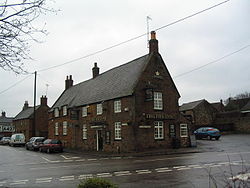
Ubicación en Northamptonshire.
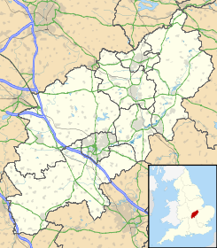
52°29′11.922″N 0°48′7.632″O / 52.486645, -0.80212Coordenadas: 52°29′11.922″N 0°48′7.632″O / 52.486645, -0.80212
Entidad Pueblo y parroquia civil
 • País Bandera del Reino Unido Reino Unido
 • Nación constitutiva Inglaterra
 • Región Midlands del Este
 • Condado Northamptonshire
 • Distrito Kettering
Población (2001)  
 • Total 767 hab.
Código postal LE16
Prefijo telefónico 01536

Wilbarston es un pueblo y una parroquia civil del distrito de Kettering, en el condado de Northamptonshire (Inglaterra).

Demografía

Según el censo de 2001,[1] Wilbarston tenía 767 habitantes (385 varones y 382 mujeres). 154 (20,08%) de ellos eran menores de 16 años, 558 (72,75%) tenían entre 16 y 74, y 55 (7,17%) eran mayores de 74. La media de edad era de 40,17 años. De los 613 habitantes de 16 o más años, 126 (20,55%) estaban solteros, 406 (66,23%) casados, y 81 (13,21%) divorciados o viudos. 375 habitantes eran económicamente activos, 368 de ellos (98,13%) empleados y otros 3 (1,87%) desempleados. Había 13 hogares sin ocupar, 298 con residentes y 3 eran alojamientos vacacionales o segundas residencias.

Evolución demográfica de Wilbarston
1801 1811 1821 1831 1841 1851 1861 1871 1881 1891 1901 1911 1921 1931 1941 1951 1961
755 599 697 681 684 754 - - 598 516 448 463 468 480 - 497 461
(Fuente:Vision of Britain )

Referencias

  1. «Wilbarston» (en inglés). Office for National Statistics. Consultado el 19 de junio de 2011.

Enlaces externos


Wikimedia foundation. 2010.

Игры ⚽ Нужен реферат?

Mira otros diccionarios:

  • Wilbarston — is a village in the English county of Northamptonshire in the valley of the River Welland, it is administered as part of the borough of Kettering.Wilbarston is only five miles, by main road (the A427), east of the Leicestershire town of Market… …   Wikipedia

  • Weston by Welland — Wilbarston Pueblo y parroquia civil del Reino Unido …   Wikipedia Español

  • Kettering (borough) — Infobox UK district name = Borough of Kettering status = Borough region = East Midlands admincounty = Northamptonshire area = Ranked 176th 233.49 km² adminhq = Kettering onscode = 34UE population = Ranked English district rank|ONS=34UE English… …   Wikipedia

  • List of places in Northamptonshire — This is a list of places in the ceremonial county of Northamptonshire, United Kingdom. See the list of places in England for places in other counties See also compactTOC NOTOC AAbington Abthorpe Achurch Adstone Alderton Aldwincle Althorp… …   Wikipedia

  • Guilsborough — is a village in the Daventry district of the county of Northamptonshire in England.It is at the centre of an area of rural villages between the towns of Northampton, Daventry, Rugby and Market Harborough. There is a secondary school, fire station …   Wikipedia

  • List of civil parishes in Northamptonshire — This is a list of civil parishes in Northamptonshire, England. Most parishes have their own parish council, but some smaller parishes may have a parish meeting, or may join together to form a combined parish council. Some larger parishes have… …   Wikipedia

  • A427 road — UK road routebox road= A427 length mi= 20 length km= 32 direction= West East start= Market Harborough destinations= Corby end= Oundle construction date= completion date= junctions= ukroadsmall|6 ukroadsmall|4304 ukroadsmall|6003 ukroadsmall|6014… …   Wikipedia

  • Northamptonshire Football Combination — The Northamptonshire Football Combination is a football competition based in England. It has a total of eight divisions (five first team divisions and three reserve divisions), the most senior of which is the Premier Division, which sits at step… …   Wikipedia

  • Oxendon Rural District — Oxendon was a rural district in Northamptonshire, England from 1894 to 1935. It was formed under the Local Government Act 1894 from the part of the Market Harborough rural sanitary district which was in Northamptonshire (the rest going on to form …   Wikipedia

  • Northamptonshire County Football Association — Northamptonshire County FA logo Purpose/focus Football association Location Moulton Park, Northampton Coordinates …   Wikipedia

Compartir el artículo y extractos

Link directo
Do a right-click on the link above
and select “Copy Link”