- Woodbastwick
-
Woodbastwick Pueblo y parroquia civil del Reino Unido 
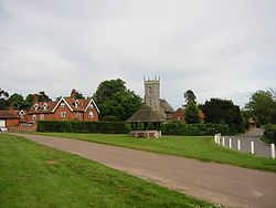
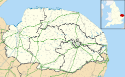
Vista de Woodbastwick.Ubicación de Woodbastwick en Norfolk. Coordenadas: Entidad Pueblo y parroquia civil • País  Reino Unido
• Nación constitutiva Inglaterra • Región Este de Inglaterra • Condado Norfolk • Distrito Broadland Superficie • Total 18.83 km² Población (2001) • Total 362 hab. • Densidad 19,22 hab/km² Huso horario GMT (UTC0) • en verano BST (UTC +1) Código postal NR13 Woodbastwick es un pueblo y una parroquia civil del distrito de Broadland, en el condado de Norfolk (Inglaterra).
Contenido
Geografía
Según la Oficina Nacional de Estadística británica, Woodbastwick tiene una superficie de 18,83 km².[1]
Demografía
Según el censo de 2001, Woodbastwick tenía 362 habitantes (51,93% varones, 48,07% mujeres) y una densidad de población de 19,22 hab/km². El 16,3% eran menores de 16 años, el 75,97% tenían entre 16 y 74, y el 7,73% eran mayores de 74. La media de edad era de 44,64 años. Del total de habitantes con 16 o más años, el 26,07% estaban solteros, el 63,7% casados, y el 10,23% divorciados o viudos.[2]
Todos los habitantes eran blancos y la mayor parte (95,86%) originarios del Reino Unido. El resto de países europeos englobaban al 1,93% de la población, mientras que el 2,21% había nacido en cualquier otro lugar. El cristianismo era profesado por el 72,22%, mientras que el 18,89% no eran religiosos y el 8,89% no marcaron ninguna opción en el censo.[1]
Había 157 hogares con residentes, 8 vacíos, y 3 eran alojamientos vacacionales o segundas residencias.[2]
Referencias
- ↑ a b Tablas: «Usual Resident Population (KS01) for Amalgamated Parishes», «Ethnic Group (KS06) for Amalgamated Parishes», «Country of Birth (KS05) for Amalgamated Parishes» y «Religion (KS07) for Amalgamated Parishes», disponibles para descarga aquí. Office for National Statistics (inglés).
- ↑ a b «Area: Woodbastwick CP (Parish)» (en inglés). Office for National Statistics. Consultado el 19 de agosto de 2011.
Enlaces externos
 Wikimedia Commons alberga contenido multimedia sobre Woodbastwick. Commons
Categorías:- Parroquias civiles de Norfolk
- Localidades de Norfolk
Wikimedia foundation. 2010.

