Woodmont (Connecticut)

Woodmont (Connecticut)
Woodmont
Borough de los Estados Unidos
Woodmont
Woodmont
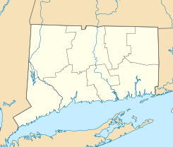
Ubicación en el condado de New Haven en el estado de Connecticut
Map of USA CT.svg
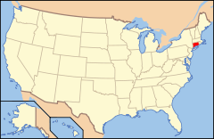
Ubicación de Connecticut en EE. UU.
41°13′41″N 72°59′32″O / 41.22806, -72.99222Coordenadas: 41°13′41″N 72°59′32″O / 41.22806, -72.99222
Entidad Borough
 • País Bandera de los Estados Unidos Estados Unidos
 • Estado Bandera de Connecticut Connecticut
 • Condado New Haven
Superficie  
 • Total 2,5 km²
 • Tierra 0,7 km²
 • Agua (71,43%) 1,8 km²
Altitud  
 • Media 12 msnm
Población (2000)  
 • Total 1 711 hab.
 • Densidad 2,377.1 hab/km²
Huso horario Este: UTC-5
 • en verano UTC-4
Código ZIP 06475
Código de área 860

Woodmont es un borough ubicado en el condado de New Haven en el estado estadounidense de Connecticut. En 2000 tenía una población de 1 711 habitantes y una densidad poblacional de 2 377,1 personas por km².[1]

Contenido

Geografía

Woodmont se encuentra ubicada en las coordenadas 41°13′41″N 72°59′32″O / 41.22806, -72.99222Coordenadas: 41°13′41″N 72°59′32″O / 41.22806, -72.99222.[2]

Demografía

Según la Oficina del Censo en 2000 los ingresos medios por hogar en la localidad eran de $61 473 y los ingresos medios por familia eran $73 281. Los hombres tenían unos ingresos medios de $41 842 frente a los $41 354 para las mujeres. La renta per cápita para la localidad era de $32 126. Alrededor del 2,5% de la población estaba por debajo del umbral de pobreza.[3]

Referencias

  1. «Encuentra un condado» (en inglés). Asociación Nacional de Condados (11 de julio de 2011). Consultado el 11 de julio de 2011.
  2. «American FactFinder» (en inglés). Oficina del Censo de los Estados Unidos. Consultado el 11 de julio de 2011.
  3. «U.S. Gazetteer: Censo de 2010» (en inglés). Oficina del Censo de los Estados Unidos (16 de febrero de 2011). Consultado el 11 de julio de 2011.

Enlaces externos


Wikimedia foundation. 2010.

Игры ⚽ Нужна курсовая?

Mira otros diccionarios:

  • Woodmont, Connecticut — Infobox Settlement official name = Woodmont, Connecticut settlement type = Borough nickname = motto = imagesize = image caption = image |pushpin pushpin label position =left pushpin map caption =Location within the state of Connecticut pushpin… …   Wikipedia

  • Woodmont — Infobox nrhp | name =Woodmont nrhp type = nhl caption = location= 1622 Spring Mill Rd., Gladwyne, Pennsylvania locmapin = Pennsylvania area = 72 acres built =1892 architect= Will Price architecture= Late 19th and 20th Century Revivals, Other… …   Wikipedia

  • Connecticut Company — (blue) and other New Haven electric railway subsidiaries The Connecticut Company was the primary electric street railway company in the U.S. state of Connecticut, operating both city and rural trolleys and freight service. It was controlled by… …   Wikipedia

  • Woodmont — Woodmont, CT U.S. borough in Connecticut Population (2000): 1711 Housing Units (2000): 817 Land area (2000): 0.277908 sq. miles (0.719778 sq. km) Water area (2000): 0.699708 sq. miles (1.812236 sq. km) Total area (2000): 0.977616 sq. miles… …   StarDict's U.S. Gazetteer Places

  • Woodmont, CT — U.S. borough in Connecticut Population (2000): 1711 Housing Units (2000): 817 Land area (2000): 0.277908 sq. miles (0.719778 sq. km) Water area (2000): 0.699708 sq. miles (1.812236 sq. km) Total area (2000): 0.977616 sq. miles (2.532014 sq. km)… …   StarDict's U.S. Gazetteer Places

  • Connecticut Transit New Haven — CT Transit New Haven Division New Flyer Industries D40LF bus on the B1 Whalley Avenue line. Parent Connecticut Department of Transportation Founded 1976 …   Wikipedia

  • Connecticut Turnpike — For the 19th century turnpike with the same name, see Connecticut Turnpike (1806). Gov. John Davis Lodge Turnpike Connecticut Turnpike Route information Maintained by …   Wikipedia

  • Connecticut Route 122 — Route 122 Route information Maintaine …   Wikipedia

  • Milford, Connecticut —   City   Milford City Hall, 110 River Street, sits along the Wepawaug River downtown. Built in 1916, it is the fifth town hall to occupy the site …   Wikipedia

  • Historical U.S. Census Totals for New Haven County, Connecticut — This article shows U.S. Census totals for New Haven County, Connecticut, broken down by municipality, from 1900 to 2000.Like most areas of New England, New Haven County is (and has been at all times since well before the 20th century) entirely… …   Wikipedia

Compartir el artículo y extractos

Link directo
Do a right-click on the link above
and select “Copy Link”